Pfingstegg - StiereggWalk 8009
Canton - Bern / Berne - Jungfrau Region
Author - Lou Johnson
Length - 5.0 km / 3.1 miles
Ascent - 260 metres / 858 feet
Descent - 260 metres / 858 feet
Time - 2.00 hours
Grade - easy/moderate
Click image to visit gallery of 10 images.
This short route provides the basis for a spectacular if short walk into the hear of the mountains with excellent views of the Lower Grindelwald glacier. The uppermost point of the walk at Stieregg benefits from a beautifully located restaurant with excellent views.
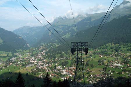
Start & End - top station of the Grindelwald to Pfingstegg cable car. This provides an easy ascent. The lower station is about one kilometre from the train and post bus stations in the centre of Grindelwald. See Transport Map for the Jungfrau Region.
After this walk was researched the restaurant at Stieregg was destroyed by a landslip. A new path was subsequently built to a temporary replacement for the restaurant on the Baregg nearby. This change slightly affects the length of the walk and increases the ascent and descent to approximately 393m.
From the top station of the Pfingstegg cablecar take the signed path to Stieregg. The first few hundred metres are deceiving as you cross a pleasant meadow. Once through this meadow, the path quickly becomes more dramatic with the Grindelwald gletscherschlucht far below on your right hand side. For most of the way to Stieregg there is a protective fence alongside the path which offers some comfort for those who suffer from fear of heights. However care must still be exercised as there is a considerable drop to the river below.
For the most part the path climbs steadily although there are a couple of rocky steps that need more agility. With steep mountainside to your left, the views are concentrated on your right hand side with an excellent view of the Eiger and its northeastern ridge. Progressing higher, the view changes and your efforts are rewarded with the ice and snow of the Lower Grindelwald Glacier. Nearing Stieregg the path descends slightly before reaching the restaurant, which is located in a grassy basin opposite the glacier.
The return route retraces your steps back to the upper station of the Pfingstegg cablecar. From here you can continue into the valley using walk 6010 or descend by the cablecar. On recent occasions walk 6010 has been closed due to a threat of falling rocks. Enquire locally for further information.
Suggested Maps
 Landeskarte der Schweiz - 1:50000 - Sheet SW 5004 - Berner Oberland
Landeskarte der Schweiz - 1:25000 - Sheet SW 2520 - Jungfrau Region
Wanderkarte - Wengen, Mürren & Lauterbrunnental - 1:40000
Recommended Books
The Tour of the Bernina
 Guidebook describing a 9-stage (119km) route around the Piz Bernina massif in the Alps on the Swiss-Italian border near St Moritz, and the 8-stage (94km) Alta Via Valmalenco exploring the Valmalenco valley, in the shadow of Monte Disgrazia. The Tour of the Bernina is suitable for first-time trekkers but the Alta Via needs some experience.
Walking in the Valais
 Comprehensive guidebook to the Valais region, describing 111 day walks and 10 multi-day tours. Home to the Matterhorn and Dent Blanche, the routes are in the Fieschertal and the Aletsch glacier region, the Lötschental, Saastal, Mattertal, Turtmanntal, Val d'Anniviers, Val d'Herens, Val de Bagnes, Val Ferret and Vallée du Trient.
Stay Safe
Do enjoy yourself when out walking and choose a route that is within your capabilities especially with regard to navigation.
Do turn back if the weather deteriorates especially in winter or when visibility is poor.
Do wear the right clothing for the anticipated weather conditions. If the weather is likely to change for the worse make sure you have enough extra clothing in your pack.
Do tell someone where you are planning to walk especially in areas that see few other walkers.
Do take maps and other navigational aids. Do not rely on mobile devices in areas where reception is poor. Take spare batteries especially in cold weather.
Do check the weather forecast before leaving.
Do do not exceed your capabilities.
Please Note - These walks have been published for use by site visitors on the understanding that Walking Sitzerland is not held responsible for the safety or well being of those following the routes as described. It is worth reiterating the point that you should embark on a walk with the correct maps at the most detailed scale where possible. This will enable any difficulties with route finding to be assessed, and corrective action taken if necessary.