Alpiglen - Eigergletscher - Kleine ScheideggWalk 8011
Canton - Bern / Berne - Jungfrau Region
Author - Lou Johnson
Length - 8.0 km / 5 miles
Ascent - 710 metres / 2343 feet
Descent - 260 metres / 858 feet
Time - 3.50 hours
Grade - moderate
Click image to visit gallery of 10 images.
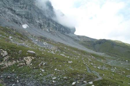
This is a straightforward route that takes you beneath the famous north wall of the Eiger. The route is well marked with "Eiger Trail" signs and providing you have good footwear you should not experience any difficulties.
Start - Alpiglen station which can be reached by regular train service from Grindelwald and Wengen. See Transport Map for the Jungfrau Region.
End - Kleine Scheidegg station from where there is a regular train service to Grindelwald and Wengen.
From Alpiglen station take the clearly signed path east. After a short way the "Eiger Trail" is signed to the right. Take this path and start to climb. Above you rises the sheer face of the North Wall. You progress past some delightful waterfalls as the path twists and turns through rocks and grass.
Nowhere is the ascent too steep, although on a hot day you will certainly feel warm by the time the path traverses across scree. Despite the dominating presence of the Eiger on your left, there are beautiful views to the right as well with the Männlichen ridge dominating the scene.
The path gets very close to the Eiger's sheer cliffs before reaching Eigergletscher station. Close by is the Eiger Glacier which can be viewed from the moraine behind the station. You may not see the marmots but you will almost certainly hear their whistles.
If you are tired or short of time then you can take the train from Eigergletscher but the descent to Kleine Scheidegg is worth completing with fine views ahead. The recommended path is the one that follows the railway. The alternative, descending down a moraine, is not so easy and best avoided unless you are very sure-footed.
Suggested Maps
 Landeskarte der Schweiz - 1:50000 - Sheet SW 5004 - Berner Oberland
Landeskarte der Schweiz - 1:25000 - Sheet SW 2520 - Jungfrau Region
Wanderkarte - Wengen, Mürren & Lauterbrunnental - 1:40000
Recommended Books
Trekking in the Silvretta and Rätikon Alps
 This guide describes three treks, between 5 and 8 days, in the Silvretta and Rätikon Alps starting near Klosters, and 12 half-day hut-to-hut routes. These contrasting ranges form a line on the borders of Switzerland, Austria and Liechtenstein. The Tour of the Silvretta, the Prättigauer Höhenweg and the Rätikon Höhenweg.
Alpine Flowers
 A pocket field guidebook for identifying 230 of the most commonly found alpine flowers of the Alps. Categorised by colour for quick identification, each alpine flower has a photograph and description of its key features. Flower names are given in English, French, German, Italian and Latin, with notes on curious facts and origins of names.
Stay Safe
Do enjoy yourself when out walking and choose a route that is within your capabilities especially with regard to navigation.
Do turn back if the weather deteriorates especially in winter or when visibility is poor.
Do wear the right clothing for the anticipated weather conditions. If the weather is likely to change for the worse make sure you have enough extra clothing in your pack.
Do tell someone where you are planning to walk especially in areas that see few other walkers.
Do take maps and other navigational aids. Do not rely on mobile devices in areas where reception is poor. Take spare batteries especially in cold weather.
Do check the weather forecast before leaving.
Do do not exceed your capabilities.
Please Note - These walks have been published for use by site visitors on the understanding that Walking Sitzerland is not held responsible for the safety or well being of those following the routes as described. It is worth reiterating the point that you should embark on a walk with the correct maps at the most detailed scale where possible. This will enable any difficulties with route finding to be assessed, and corrective action taken if necessary.