Alp Suvretta - SpinasWalk 8017
Canton - Graubunden/Grisons - Upper Engadine
Author - Lou Johnson
Length - 5.0 km / 3.1 miles
Ascent - nominal or unknown
Descent - 330 metres / 1089 feet
Time - 1.50 hours
Grade - easy/moderate
Click image to visit gallery of 6 images.
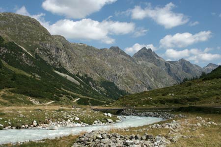
Val Bever is sandwiched between two mountain ridges. Different in character than the valley from Pass Suvretta to Alp Suvretta, its lower altitude is reflected in its vegetation with extensive plantations of conifer trees as you progress towards Spinas.
Start - Alp Suvretta. No mechanical means of reaching here. Walk 8015 and Walk 8016 provide an enjoyable way of extending this route.
End - Spinas railway station served by trains on the Albula route between St.Moritz, Samedan and Filisur. Note the train service is not very regular by Swiss standards. Alternatively you can reach Bever with a more frequent rail service by following Walk 8018.
Leave Alp Suvretta in an easterly direction and follow the clear track that follows the south side of the river. Quite soon the track transfers to the northern side of the river. The onward route is never in doubt and you soon arrive at Spinas with its restaurant and railway station without any navigational difficulties.,
To continue this route follow Walk 8018.
Suggested Maps
 Landeskarte der Schweiz - 1:50000 - Sheet SW 5013 - Oberengadin - Engiadin'Ota
Landeskarte der Schweiz - 1:25000 - Sheet SW 2521 - Engadin
Oberengadin, Bergell-Puschlav, Wanderkarte - 1:50000
Recommended Books
Walking in the Valais
 Comprehensive guidebook to the Valais region, describing 111 day walks and 10 multi-day tours. Home to the Matterhorn and Dent Blanche, the routes are in the Fieschertal and the Aletsch glacier region, the Lötschental, Saastal, Mattertal, Turtmanntal, Val d'Anniviers, Val d'Herens, Val de Bagnes, Val Ferret and Vallée du Trient.
Walks in the Engadine - Switzerland
 A walking guidebook to 100 day walks in the Engadine, Val Bregaglia, neighbouring valleys and the Engadine National Park. Varying from gentle rambles to adventurous high-level routes for the experienced mountain walker. Each route ranges from 2 to 10 miles long, visiting forests and meadows, high mountain landscapes, lakes and passes.
Stay Safe
Do enjoy yourself when out walking and choose a route that is within your capabilities especially with regard to navigation.
Do turn back if the weather deteriorates especially in winter or when visibility is poor.
Do wear the right clothing for the anticipated weather conditions. If the weather is likely to change for the worse make sure you have enough extra clothing in your pack.
Do tell someone where you are planning to walk especially in areas that see few other walkers.
Do take maps and other navigational aids. Do not rely on mobile devices in areas where reception is poor. Take spare batteries especially in cold weather.
Do check the weather forecast before leaving.
Do do not exceed your capabilities.
Please Note - These walks have been published for use by site visitors on the understanding that Walking Sitzerland is not held responsible for the safety or well being of those following the routes as described. It is worth reiterating the point that you should embark on a walk with the correct maps at the most detailed scale where possible. This will enable any difficulties with route finding to be assessed, and corrective action taken if necessary.