Diavolezza - Munt Pers - DiavolezzaWalk 8024
Canton - Graubunden/Grisons - Upper Engadine
Author - Lou Johnson
Length - 4.0 km / 2.5 miles
Ascent - 315 metres / 1040 feet
Descent - 215 metres / 710 feet
Time - 2.50 hours
Grade - easy/moderate
Click image to visit gallery of 6 images.
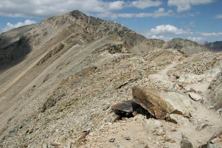
Despite being a short walk, it is over rough ground and at an altitude in excess of 3,200 m (10,500 ft) so may cause a few problems if you are not used to strenuous effort at this altitude. The effort is however well rewarded with excellent views of glaciers, the surrounding valleys and mountains.
Start & End - The mountain station of the Diavolezza Cablecar which can be reached by train on the Bernina Railway between Pontresina and Alp Grüm with connections from many other places in the region. See Transport Map - Upper Engadine for details. See Transport Map for the Upper Engadine Region.
The footpath to Mun Pers is clearly signed from the cablecar station where there are ample refreshment facilities and toilets. The path immediately offers excellent views south to the pers Glacier with Piz Palü and Piz Bernina the principal mountain peaks.
The path climbs steadily amidst rocky surroundings before losing height for a short way. There then follows a steeper ascent that eventually leads you to the summit cairn (3207 m. - 10521 ft.). This offers a tremendous view northwest into the Bernina valley with Pontresina on its eastern side.
There are no refreshments at the summit so I recommend taking a drink with you and taking plenty of time to enjoy the view. The return route follows the outward path.
Suggested Maps
 Landeskarte der Schweiz - 1:50000 - Sheet SW 5013 - Oberengadin - Engiadin'Ota
Landeskarte der Schweiz - 1:25000 - Sheet SW 2521 - Engadin
Oberengadin, Bergell-Puschlav, Wanderkarte - 1:50000
Recommended Books
Tour of Mont Blanc
 An essential guidebook for walking the Tour of Mont Blanc. The 170km route typically takes 11 days to trek around the Mont Blanc massif. The TMB is recognised as one of the world's classic treks. The book describes both anti-clockwise and clockwise directions, with variants and information about huts, refuges and facilities en route.
The Swiss Alpine Pass Route - Via Alpina Route 1
 Guidebook to the Alpine Pass Route following the Swiss Via Alpina 1, a 360km trek east-west across Switzerland, from Sargans, on the border of Liechtenstein, to Montreux, including prologue from Liechtenstein. A demanding 3-week trek described in 18 stages, crossing 16 passes including the 2778m Hohtürli. Requires good fitness and experience.
Stay Safe
Do enjoy yourself when out walking and choose a route that is within your capabilities especially with regard to navigation.
Do turn back if the weather deteriorates especially in winter or when visibility is poor.
Do wear the right clothing for the anticipated weather conditions. If the weather is likely to change for the worse make sure you have enough extra clothing in your pack.
Do tell someone where you are planning to walk especially in areas that see few other walkers.
Do take maps and other navigational aids. Do not rely on mobile devices in areas where reception is poor. Take spare batteries especially in cold weather.
Do check the weather forecast before leaving.
Do do not exceed your capabilities.
Please Note - These walks have been published for use by site visitors on the understanding that Walking Sitzerland is not held responsible for the safety or well being of those following the routes as described. It is worth reiterating the point that you should embark on a walk with the correct maps at the most detailed scale where possible. This will enable any difficulties with route finding to be assessed, and corrective action taken if necessary.