Kleine Scheidegg - AlpiglenWalk 8028
Canton - Bern / Berne - Jungfrau Region
Author - Lou Johnson
Length - 4.0 km / 2.5 miles
Ascent - nominal or unknown
Descent - 445 metres / 1469 feet
Time - 1.00 hours
Grade - easy
Click image to visit gallery of 6 images.
The path connecting Kleine Scheidegg to Alpiglen offers some wonderful views to the north face of the Eiger. The views ahead over Grindelwald are also good.
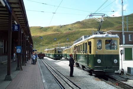
Start Kleine Scheidegg station, which is served by trains from Grindelwald, Wengen and Lauterbrunnen. See Transport Map for the Jungfrau Region.
End Alpiglen station for trains to Grindelwald or Wengen (via Kleine Scheidegg)
Kleine Scheidegg is rarely quiet and generally bustles from morning to late afternoon. The path to Alpiglen starts at the rear of the station building adjacent to the platform from where trains to Grindelwald depart. Initially the path shadows the railway as it descends into the valley. Soon it drifts away from the railway to reach the first junction where you bear right.
The path continues to meander downhill to the cluster of buildings at Mettla. From here the onward route is never in doubt as you maintain a steady descent towards Alpiglen station crossing the railway a short way from the end of the walk. In the afternoon descending trains to Grindelwald can be busy. However on busy days some trains start empty at Alpiglen.
Suggested Maps
 Landeskarte der Schweiz - 1:50000 - Sheet SW 5004 - Berner Oberland
Landeskarte der Schweiz - 1:25000 - Sheet SW 2520 - Jungfrau Region
Wanderkarte - Wengen, Mürren & Lauterbrunnental - 1:40000
Recommended Books
Tour of Mont Blanc
 An essential guidebook for walking the Tour of Mont Blanc. The 170km route typically takes 11 days to trek around the Mont Blanc massif. The TMB is recognised as one of the world's classic treks. The book describes both anti-clockwise and clockwise directions, with variants and information about huts, refuges and facilities en route.
Walks in the Engadine - Switzerland
 A walking guidebook to 100 day walks in the Engadine, Val Bregaglia, neighbouring valleys and the Engadine National Park. Varying from gentle rambles to adventurous high-level routes for the experienced mountain walker. Each route ranges from 2 to 10 miles long, visiting forests and meadows, high mountain landscapes, lakes and passes.
Stay Safe
Do enjoy yourself when out walking and choose a route that is within your capabilities especially with regard to navigation.
Do turn back if the weather deteriorates especially in winter or when visibility is poor.
Do wear the right clothing for the anticipated weather conditions. If the weather is likely to change for the worse make sure you have enough extra clothing in your pack.
Do tell someone where you are planning to walk especially in areas that see few other walkers.
Do take maps and other navigational aids. Do not rely on mobile devices in areas where reception is poor. Take spare batteries especially in cold weather.
Do check the weather forecast before leaving.
Do do not exceed your capabilities.
Please Note - These walks have been published for use by site visitors on the understanding that Walking Sitzerland is not held responsible for the safety or well being of those following the routes as described. It is worth reiterating the point that you should embark on a walk with the correct maps at the most detailed scale where possible. This will enable any difficulties with route finding to be assessed, and corrective action taken if necessary.