Schwarenbach - SunnbuelWalk 8043
Canton - Valais / Wallis - Leukerbad & Gemmipass
Canton - Bern / Berne - Kandertal
Author - Lou Johnson
Length - 4.0 km / 2.5 miles
Ascent - 40 metres / 132 feet
Descent - 140 metres / 462 feet
Time - 1.00 hours
Grade - easy
Click image to visit gallery image.
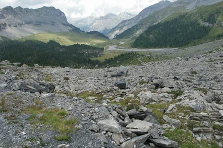
This route from the Berghotel Schwarenbach offers an easy route through a wide valley. The walk offers some excellent mountain views on easy to follow paths.
Start the Berghotel Schwarenbach. No mechanical means of reaching here from the valley. Walk 8042 provides a very pleasant approach.
End the upper station of the Luftseilbahn Kandersteg-Sunnbüel. See Transport Map for the Kandertal Region.
This is a straightforward walk which crosses the border from Valais/Wallis into the Canton of Bern. Leave the Berghotel Schwarenbach and walk north on the path signed to Sunnbüel. Initially the route passes through a barren landscape but this soon changes as you begin to descend into a wide valley.
After Spittelmatte the views to the left of the Üschenegrat ridge improve. Reaching a junction of paths/tracks continue straight ahead climbing gently to the upper station of the cable car at Sunnbüel.
Suggested Maps
 Landeskarte der Schweiz - 1:50000 - Sheet SW 5004 - Berner Oberland
Landeskarte der Schweiz - 1:50000 - Sheet SW5009 - Gstaad - Adelboden
Kandersteg Wanderkarte - 1:25000
Recommended Books
Walking in the Alps
 An outstanding and comprehensive book exploring the walking and trekking possibilities in every Alpine region. Many thousands of possible routes are suggested, from the Maritime Alps of southern France throughout the range to the Julian Alps of Slovenia. Walks vary from undemanding to long and tough, and everything in between.
Walking in the Bernese Oberland
 This walking guidebook to the Bernese Oberland describes 113 day walks. Routes range from 2 to 24km and offer breathtaking scenery of the classic Eiger, Mönch and Jungfrau mountains, around Grindelwald, Lauterbrunnen, Gsteig and Meiringen. There are routes suitable for all abilities from short flat walks to adventurous treks.
Stay Safe
Do enjoy yourself when out walking and choose a route that is within your capabilities especially with regard to navigation.
Do turn back if the weather deteriorates especially in winter or when visibility is poor.
Do wear the right clothing for the anticipated weather conditions. If the weather is likely to change for the worse make sure you have enough extra clothing in your pack.
Do tell someone where you are planning to walk especially in areas that see few other walkers.
Do take maps and other navigational aids. Do not rely on mobile devices in areas where reception is poor. Take spare batteries especially in cold weather.
Do check the weather forecast before leaving.
Do do not exceed your capabilities.
Please Note - These walks have been published for use by site visitors on the understanding that Walking Sitzerland is not held responsible for the safety or well being of those following the routes as described. It is worth reiterating the point that you should embark on a walk with the correct maps at the most detailed scale where possible. This will enable any difficulties with route finding to be assessed, and corrective action taken if necessary.