First - Stand - KanderstegWalk 8045
Canton - Bern / Berne - Kandertal
Author - Lou Johnson
Length - 7.0 km / 4.4 miles
Ascent - 100 metres / 330 feet
Descent - 1375 metres / 4538 feet
Time - 3.50 hours
Grade - moderate/hard
Click image to visit gallery of 9 images.
This descent from First to the Kandersteg is long and tiring. However it offers some fine walking with excellent views across the Kander Valley to the Blümlisalp and Öeschinensee. After heavy rain there are two river crossings that might prove impossible.
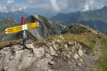
Start the summit of First (2549m). No mechanical means of reaching here from the valley. Walk 8044 provides a very pleasant approach.
End Kandersteg Railway Station. See Transport Map for the Kandertal Region.
Descend north from the summit of First following the sign for Kandersteg. There is one section of cable to assist the descent before the path drops to the left hand side of the ridge before continuing onto the summit of Stand (2320m). This offers similar views to First and can be seen as you approach along the ridge.
The path drops steeply of the summit of Stand before traversing across its northern flank to reach the col of Gölitschehöri. Here you descend east using loops and zigzags to reach Gölitschealp. The path turns south and descends to cross a major stream. This could be problematic in spate. Continuing the path descends through conifer forest to reach the more amenable environment of open pastures nearer to Kandersteg.
Suggested Maps
 Landeskarte der Schweiz - 1:50000 - Sheet SW 5004 - Berner Oberland
Landeskarte der Schweiz - 1:50000 - Sheet SW5009 - Gstaad - Adelboden
Kandersteg Wanderkarte - 1:25000
Recommended Books
Tour of Mont Blanc
 An essential guidebook for walking the Tour of Mont Blanc. The 170km route typically takes 11 days to trek around the Mont Blanc massif. The TMB is recognised as one of the world's classic treks. The book describes both anti-clockwise and clockwise directions, with variants and information about huts, refuges and facilities en route.
Trekking in the Silvretta and Rätikon Alps
 This guide describes three treks, between 5 and 8 days, in the Silvretta and Rätikon Alps starting near Klosters, and 12 half-day hut-to-hut routes. These contrasting ranges form a line on the borders of Switzerland, Austria and Liechtenstein. The Tour of the Silvretta, the Prättigauer Höhenweg and the Rätikon Höhenweg.
Stay Safe
Do enjoy yourself when out walking and choose a route that is within your capabilities especially with regard to navigation.
Do turn back if the weather deteriorates especially in winter or when visibility is poor.
Do wear the right clothing for the anticipated weather conditions. If the weather is likely to change for the worse make sure you have enough extra clothing in your pack.
Do tell someone where you are planning to walk especially in areas that see few other walkers.
Do take maps and other navigational aids. Do not rely on mobile devices in areas where reception is poor. Take spare batteries especially in cold weather.
Do check the weather forecast before leaving.
Do do not exceed your capabilities.
Please Note - These walks have been published for use by site visitors on the understanding that Walking Sitzerland is not held responsible for the safety or well being of those following the routes as described. It is worth reiterating the point that you should embark on a walk with the correct maps at the most detailed scale where possible. This will enable any difficulties with route finding to be assessed, and corrective action taken if necessary.