Kreuzboden - Gspon (Gspon Höhenweg) Walk 8050
Canton - Valais / Wallis - Saastal
Author - Lou Johnson
Length - 13.0 km / 8.1 miles
Ascent - 140 metres / 462 feet
Descent - 650 metres / 2145 feet
Time - 5.50 hours
Grade - moderate
Click image to visit gallery of 15 images.
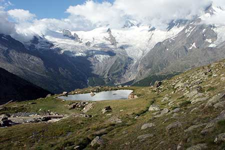
The Gspon Höhenweg is one of the classic walks of Saastal offering extended panoramas throughout. To reach the start take Kreuzboden lift from the northern outskirts of Saas Grund and exit the station. The route is well signed and all you need to do is follow the signs for Gspon. Almost immediately you will pass a man-made reservoir on your left as you cross the northern side of a basin to reach Hannig (2445 m) which is the highest part of the walk. Here ignore the path heading downhill and continue crossing a large boulder field to descend to Grüebe (2300m)
The onward route stays relatively level and reaches the buildings at Hoferälpji after which you join a clear track. Little description is necessary as the route ahead is always obvious leading you through to a single house at Obere Schwarzwalde (2200m). All you need to do is relax, walk and enjoy the views although there is a section where care is needed as you cross the Leidbach river.
After this it is easy walking across Alpine pastures until pass the small chapel above the path on the final approach to Gspon. The cable car station is easy to find and provides a moment of excitement as you glide down to the valley station at Stalden. Unusually there is an intermediate station which in itself is not a problem when you descend. More concerting is the fact that after picking up passengers you come to a stop hanging over a gorge with a river far below - this is to allow passengers on the ascending car to disembark at the intermediate stop!
Public transport in the area is good. There is a regular postbus service back to Saas Grund, Saas Fee and Saas Almagell. In addition, trains link Stalden with Zermatt and Brig.
Suggested Maps
 Landeskarte der Schweiz - 1:50000 - Sheet SW 5006 - Matterhorn/Mischabel
Recommended Books
The Swiss Alps
 A comprehensive guidebook to every mountain area in the Swiss Alps. This handy resource includes information for walking, hiking, trekking, climbing and ski mountaineering. Access, accommodation and facilities in the valley bases and full information about Swiss mountain huts is included to help you make the most out of a trip there.
Trekking in the Silvretta and Rätikon Alps
 This guide describes three treks, between 5 and 8 days, in the Silvretta and Rätikon Alps starting near Klosters, and 12 half-day hut-to-hut routes. These contrasting ranges form a line on the borders of Switzerland, Austria and Liechtenstein. The Tour of the Silvretta, the Prättigauer Höhenweg and the Rätikon Höhenweg.
Stay Safe
Do enjoy yourself when out walking and choose a route that is within your capabilities especially with regard to navigation.
Do turn back if the weather deteriorates especially in winter or when visibility is poor.
Do wear the right clothing for the anticipated weather conditions. If the weather is likely to change for the worse make sure you have enough extra clothing in your pack.
Do tell someone where you are planning to walk especially in areas that see few other walkers.
Do take maps and other navigational aids. Do not rely on mobile devices in areas where reception is poor. Take spare batteries especially in cold weather.
Do check the weather forecast before leaving.
Do do not exceed your capabilities.
Please Note - These walks have been published for use by site visitors on the understanding that Walking Sitzerland is not held responsible for the safety or well being of those following the routes as described. It is worth reiterating the point that you should embark on a walk with the correct maps at the most detailed scale where possible. This will enable any difficulties with route finding to be assessed, and corrective action taken if necessary.