Trient - Col de Balme - Croix de FerWalk 8103
Canton - Valais / Wallis - Vallee du Trient
Author - Trient Office de Tourisme
Length - 6.0 km / 3.8 miles
Ascent - 1100 metres / 3630 feet
Descent - nominal or unknown
Time - 3.75 hours
Grade - moderate
Click image to visit gallery of 3 images.
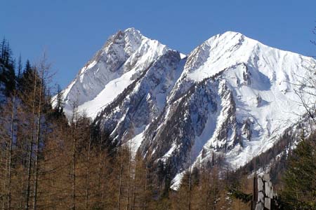
A grand hike into the mountains to reach a superb viewpoint overlooking the village of Trient. In addition to an excellent panorama across Switzerland you also benefit from seeing Mont Blanc and the mountains around Chamonix in France.
Start & End - the village of Trient, 10 km. southwest of Martigny (VS).
From the village of Trient follow the road to Le Peuty. From here take the signed path to Col de Balme. You are now following a section of the 'Tour du Mont Blanc'. The path crosses meadows to cross the Nant Noir stream.
The climb now begins as the path zigzags through trees. Leaving the trees, you climb more easily across mountain pastures to the huts at Les Herbagères. Shortly afterwards the zigzags reappear and the gradient steepens for the final pull up to the Col de Balme with its sturdy stone-built refuge (refreshments in season).
The Col is on the Swiss-French frontier and the onward path bears left before reaching the refuge. The path continues to a small Col between the Tête de Balme and the Croix de Fer. Reaching this Col fork right to follow the narrow path that climbs to the airy summit of the Croix de Fer (2343 m.). The cross itself is located on the north side just beyond the summit.
Suggested Maps
 Landeskarte der Schweiz - 1:50000 - Sheet SW 5003 - Mont Blanc - Grand Combin
Recommended Books
Tour of the Jungfrau Region
 A guidebook to the Tour of the Jungfrau Region, a 111km trek from Schynige Platte to Wilderswil in 9-12 days through the Bernese Oberland under the Mönch, Eiger and Jungfrau, exploring both well-known and hidden valleys, surrounded by soaring peaks, glaciers, lakes and ridges. A good first Alpine trek with plenty of bad-weather alternatives.
The Swiss Alpine Pass Route - Via Alpina Route 1
 Guidebook to the Alpine Pass Route following the Swiss Via Alpina 1, a 360km trek east-west across Switzerland, from Sargans, on the border of Liechtenstein, to Montreux, including prologue from Liechtenstein. A demanding 3-week trek described in 18 stages, crossing 16 passes including the 2778m Hohtürli. Requires good fitness and experience.
Stay Safe
Do enjoy yourself when out walking and choose a route that is within your capabilities especially with regard to navigation.
Do turn back if the weather deteriorates especially in winter or when visibility is poor.
Do wear the right clothing for the anticipated weather conditions. If the weather is likely to change for the worse make sure you have enough extra clothing in your pack.
Do tell someone where you are planning to walk especially in areas that see few other walkers.
Do take maps and other navigational aids. Do not rely on mobile devices in areas where reception is poor. Take spare batteries especially in cold weather.
Do check the weather forecast before leaving.
Do do not exceed your capabilities.
Please Note - These walks have been published for use by site visitors on the understanding that Walking Sitzerland is not held responsible for the safety or well being of those following the routes as described. It is worth reiterating the point that you should embark on a walk with the correct maps at the most detailed scale where possible. This will enable any difficulties with route finding to be assessed, and corrective action taken if necessary.