Piz Lunghin from MalojaWalk 8114
Canton - Graubunden/Grisons - Upper Engadine
Author - Peter Smyly
Ascent - 900 metres / 2970 feet
Descent - 900 metres / 2970 feet
Grade - moderate/hard
Click image to visit gallery of 6 images.
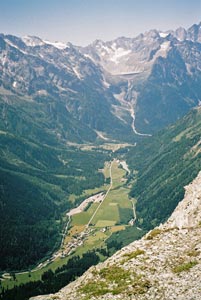
Piz Lunghin (9,121 feet, 2,780 metres) is a mountain in the Swiss canton of Graubünden in the Albula range. The starting point for the walk is the Swiss ski resort of Maloja which is situated at the upper end of the Engadin (east) and Bregaglia (west) valleys. The Maloja Pass, which connects the two valleys, is located 2 kilometres south-east of the peak.
This walk includes magnificent distant views of mountain peaks, valleys, forests and lakes, a picturesque mountain lake (Lake Lunghin) with crystal clear waters on the way up, a narrow ridge to negotiate at one point and a steepish climb up to a summit where you can hang your feet over the edge and drink in the all-round views including the route up to the top from the starting point, set out before you in birds-eye format. I should add that the drop over the edge is just a few feet, so there is no question of vertigo or danger. However, unlike the walk up Piz Languard from Pontresina, this time you need to be entirely self-sufficient as there are no chair lifts to take you part of the way up or mountain hut cafes to supply you with refreshments. But the rewards for your efforts in climbing up are tremendous in the right weather conditions with views that will live long in the memory. There are some parts of the walk where you pass close to sections of the mountain which are very steep with loose, crumbling rock faces and screes but nowhere are there any sheer drops as long as you stick to the signed walking trails.
If travelling to Maloja by bus, for instance from Pontresina, the starting point is the bus terminal. From here, walk along the main road north-east and turn off it on the left to follow a path which heads up grassy slopes towards a waterfall, with rocky mountains above. As the gradient eases off, the objective of the walk is now seen to the left as a pyramid-like shape of mountain with smooth rocky sides which, while not vertical, appear impossibly steep for walkers to ascend. However, the route to the top takes an easier and more circuitous approach. The route ahead descends briefly as a turquoise and picturesque mountain lake comes into view ahead, Lake Lunghin.
The lake, overlooked by a mountain called Piz Grevasalvas, has a turquoise colour and is backed by a mixture of loose scree slopes and steep rock faces where, even in summer, patches of snow still linger. The way to the top of Piz Lunghin is via a footpath which crosses a snow field with Piz Lunghin seen to the left in the distance beyond scree-covered slopes. At the top of the ridge, there are some weird and unusual-looking rock formations like towers that are leaning to one side, though not towards the path. At this juncture, the landscape has an almost lunar-like appearance to it with a footpath crossing a barren, stony area. A narrow ridge follows next with a steep, though not vertical, drop down to the right with steep rocky slopes leading all the way down to a valley around three thousand feet below. Anybody of a nervous disposition may feel out of their comfort zone here, although this section is sufficiently wide to not cause any undue alarm. This stretch is short-lived before the path climbs up steeply with the dome-shaped top clearly seen ahead, the path veering left to steer clear of what appears to be crumbling rock faces to the right. The summit is just a few minutes walk from this point. Geologists may be interested in looking out for pieces of green rock underfoot. The view from the top is well worth pausing to have a long look at with mountains, lakes and valleys in view. Lake Lunghin can be seen below and, Maloja is also seen some three thousand feet below. For the descent, a pathless route back down to lake Lunghin offers a more direct approach, taking care with loose stones, rather than reversing the ascent route in its entirety.
Suggested Maps
 Landeskarte der Schweiz - 1:50000 - Sheet SW 5013 - Oberengadin - Engiadin'Ota
Landeskarte der Schweiz - 1:25000 - Sheet SW 2521 - Engadin
Oberengadin, Bergell-Puschlav, Wanderkarte - 1:50000
Recommended Books
The Tour of the Bernina
 Guidebook describing a 9-stage (119km) route around the Piz Bernina massif in the Alps on the Swiss-Italian border near St Moritz, and the 8-stage (94km) Alta Via Valmalenco exploring the Valmalenco valley, in the shadow of Monte Disgrazia. The Tour of the Bernina is suitable for first-time trekkers but the Alta Via needs some experience.
The Swiss Alpine Pass Route - Via Alpina Route 1
 Guidebook to the Alpine Pass Route following the Swiss Via Alpina 1, a 360km trek east-west across Switzerland, from Sargans, on the border of Liechtenstein, to Montreux, including prologue from Liechtenstein. A demanding 3-week trek described in 18 stages, crossing 16 passes including the 2778m Hohtürli. Requires good fitness and experience.
Stay Safe
Do enjoy yourself when out walking and choose a route that is within your capabilities especially with regard to navigation.
Do turn back if the weather deteriorates especially in winter or when visibility is poor.
Do wear the right clothing for the anticipated weather conditions. If the weather is likely to change for the worse make sure you have enough extra clothing in your pack.
Do tell someone where you are planning to walk especially in areas that see few other walkers.
Do take maps and other navigational aids. Do not rely on mobile devices in areas where reception is poor. Take spare batteries especially in cold weather.
Do check the weather forecast before leaving.
Do do not exceed your capabilities.
Please Note - These walks have been published for use by site visitors on the understanding that Walking Sitzerland is not held responsible for the safety or well being of those following the routes as described. It is worth reiterating the point that you should embark on a walk with the correct maps at the most detailed scale where possible. This will enable any difficulties with route finding to be assessed, and corrective action taken if necessary.