Grosse Scheidegg - FirstWalk 8007
Canton - Bern / Berne - Jungfrau Region
Author - Lou Johnson
Length - 4.0 km / 2.5 miles
Ascent - 305 metres / 1007 feet
Descent - 100 metres / 330 feet
Time - 1.50 hours
Grade - easy
Click image to visit gallery of 9 images.
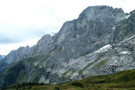
This is a straightforward hike on well maintained footpaths. Even the ascent is hardly noticeable as the views across the valley to the Wetterhorn, Schrekhorn and Eiger occupy your mind.
Start - the hotel at Grosse Scheidegg which can be reached by Postbus from Grindelwald and Meiringen. See Transport Map for the Jungfrau Region.
End - top station of the Grindelwald to First gondola lift. This provides a comfortable and scenic descent with connections in Grindelwald by train and post bus to destinations throughout the area.
From Grosse Scheidegg take the signed path to First that heads north with the slopes of the Schwarzhorn ahead. The path climbs gently crossing a small hill (Chiemattenhubla) before descending again to a junction of paths and tracks at Gratschären. A track and a path go left. Ignore the lower track that leads to Oberläger instead taking the clear footpath that runs above it.
This path is a delight, offering views south over Grindelwald to the mountains and glaciers beyond. The immediate landscape is rough grassland that rises on your right to the interestingly shaped summit of the Schwarzhorn. The path climbs a little, meandering across the mountainside crossing a number of small streams on the way.
The end of the route is the top station of the Grindelwald - First Gondola lift which soon comes into view.
Suggested Maps
 Landeskarte der Schweiz - 1:50000 - Sheet SW 5004 - Berner Oberland
Landeskarte der Schweiz - 1:25000 - Sheet SW 2520 - Jungfrau Region
Wanderkarte - Wengen, Mürren & Lauterbrunnental - 1:40000
Recommended Books
Walking in the Valais
 Comprehensive guidebook to the Valais region, describing 111 day walks and 10 multi-day tours. Home to the Matterhorn and Dent Blanche, the routes are in the Fieschertal and the Aletsch glacier region, the Lötschental, Saastal, Mattertal, Turtmanntal, Val d'Anniviers, Val d'Herens, Val de Bagnes, Val Ferret and Vallée du Trient.
Walking in the Alps
 An outstanding and comprehensive book exploring the walking and trekking possibilities in every Alpine region. Many thousands of possible routes are suggested, from the Maritime Alps of southern France throughout the range to the Julian Alps of Slovenia. Walks vary from undemanding to long and tough, and everything in between.
Stay Safe
Do enjoy yourself when out walking and choose a route that is within your capabilities especially with regard to navigation.
Do turn back if the weather deteriorates especially in winter or when visibility is poor.
Do wear the right clothing for the anticipated weather conditions. If the weather is likely to change for the worse make sure you have enough extra clothing in your pack.
Do tell someone where you are planning to walk especially in areas that see few other walkers.
Do take maps and other navigational aids. Do not rely on mobile devices in areas where reception is poor. Take spare batteries especially in cold weather.
Do check the weather forecast before leaving.
Do do not exceed your capabilities.
Please Note - These walks have been published for use by site visitors on the understanding that Walking Sitzerland is not held responsible for the safety or well being of those following the routes as described. It is worth reiterating the point that you should embark on a walk with the correct maps at the most detailed scale where possible. This will enable any difficulties with route finding to be assessed, and corrective action taken if necessary.