Spinas - BeverWalk 8018
Canton - Graubunden/Grisons - Upper Engadine
Author - Lou Johnson
Length - 4.0 km / 2.5 miles
Ascent - nominal or unknown
Descent - 110 metres / 363 feet
Time - 0.75 hours
Grade - easy
Click image to visit gallery of 9 images.
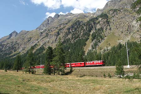
A short walk in a pleasant valley with a grand finale. Spinas is the eastern end of the 5865 metre long Albula tunnel which takes the Rhätische Railway from the Engadine valley to the Upper Albula valley at Preda.
Start - Spinas railway station served by trains on the Albula route between St.Moritz, Samedan and Filisur. Note the train service is not very regular by Swiss standards.
End - Bever railway station from where services to Zuoz, St.Moritz, Samedan and other stations in the area are available. In addition buses to Zuoz and Samedan also operate.
Leaving Spinas follow the wide path on the south side of the railway signed to Bever. As you walk you will no doubt see trains of the Rhätische Railway with their red livery contrasting with the colours of the mountains and pastures. About a kilometre before Bever the path crosses the railway and continues through meadows into Bever.
At first glance you might be tempted to ignore the village as much of what you have seen on the approach is of recent construction. However there are many architectural delights within the older part of the village and you would miss a visual and historic treat by not exploring the narrow streets and lanes. As in most villages the church provides a focal point and most of the older buildings which date back to the 16th century are built nearby.
There is no recommended route through the village which makes a stroll a journey of exploration with pleasant surprises around each corner. Having completed your exploration the railway station is located on the main road to the southwest of the church.
As an alternative you can make this an out and back route starting either from Spinas or perhaps more conveniently from Bever.
Suggested Maps
 Landeskarte der Schweiz - 1:50000 - Sheet SW 5013 - Oberengadin - Engiadin'Ota
Landeskarte der Schweiz - 1:25000 - Sheet SW 2521 - Engadin
Oberengadin, Bergell-Puschlav, Wanderkarte - 1:50000
Recommended Books
100 Hut Walks in the Alps
 This guidebook has route descriptions for 100 day walks to suit alpine walkers of all abilities, with suggestions for some hut-to-hut tours. These routes take you through breathtaking scenery in the Maritime Alps, Julian Alps, Gran Paradiso, the Turnitzer Alps, Bernese Oberland, the Kitzbuheler Alps and the Dolomites of South Tirol.
Walks in the Engadine - Switzerland
 A walking guidebook to 100 day walks in the Engadine, Val Bregaglia, neighbouring valleys and the Engadine National Park. Varying from gentle rambles to adventurous high-level routes for the experienced mountain walker. Each route ranges from 2 to 10 miles long, visiting forests and meadows, high mountain landscapes, lakes and passes.
Stay Safe
Do enjoy yourself when out walking and choose a route that is within your capabilities especially with regard to navigation.
Do turn back if the weather deteriorates especially in winter or when visibility is poor.
Do wear the right clothing for the anticipated weather conditions. If the weather is likely to change for the worse make sure you have enough extra clothing in your pack.
Do tell someone where you are planning to walk especially in areas that see few other walkers.
Do take maps and other navigational aids. Do not rely on mobile devices in areas where reception is poor. Take spare batteries especially in cold weather.
Do check the weather forecast before leaving.
Do do not exceed your capabilities.
Please Note - These walks have been published for use by site visitors on the understanding that Walking Sitzerland is not held responsible for the safety or well being of those following the routes as described. It is worth reiterating the point that you should embark on a walk with the correct maps at the most detailed scale where possible. This will enable any difficulties with route finding to be assessed, and corrective action taken if necessary.