Oeschinensee - KanderstegWalk 8032
Canton - Bern / Berne - Kandertal
Author - Lou Johnson
Length - 6.0 km / 3.8 miles
Ascent - nominal or unknown
Descent - 510 metres / 1683 feet
Time - 2.00 hours
Grade - easy/moderate
Click image to visit gallery of 3 images.
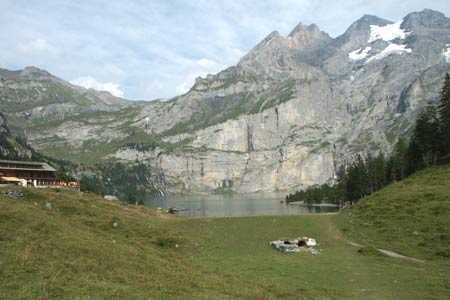
The Öeschinensee is beautifully situated above Kandersteg with the Blümlisalp soaring skywards from its shores. This walk visits Öeschinensee and follows its shore before descending into the valley.
Start Upper station of the Sesselbahn Öeschinen from Kandersteg. The valley station is a few minutes walk from Kandersteg Railway Station. See Transport Map for the Kandertal Region.
End Kandersteg Railway Station. Regular trains from Spiez (with connections from Interlaken) and Brig. Also bus service from Frutigen.
Exit the upper station of the chairlift and follow the wide path signed towards the Öeschinensee. Ahead the Blümlisalp and its satellite peaks provide a wonderful panorama. Where the main path descending to the hotels bears right, continue ahead on a narrower path. The path passes through a landscape of scattered woodland.
Soon you pass the junction for the Blümlisalphütte, which forks off to the left. At the next junction (above the barns at Läger) bear left and continue on this lower path to the Blümlisalphütte. This leads down towards the shores of the lake. At the next junction turn sharp right and continue along this lakeshore path with some fine views to the Blümlisalp. This path leads to the hotels and restaurants at the outlet to the lake. One option from here is to take the main signed path directly back to the chairlift.
The onward route into the valley is signed to Kandersteg and is easy to follow. The easier route is to bear left at the first junction from where you descend to a cross junction of paths/tracks. Bear left here and then descend to Kandersteg with the river on your right. Just under one kilometre from this last junction, bear right off the main track and follow a clear path through the forest. Reaching a substantial bridge over the river, cross to the other side. Turn left and continue to follow the river into Kandersteg with the river now on your left. Reaching the main road, turn right and continue into the centre of the village.
Suggested Maps
 Landeskarte der Schweiz - 1:50000 - Sheet SW 5004 - Berner Oberland
Landeskarte der Schweiz - 1:50000 - Sheet SW5009 - Gstaad - Adelboden
Kandersteg Wanderkarte - 1:25000
Recommended Books
Across the Eastern Alps: E5
 From Lake Constance in Germany, this guidebook describes walking the E5 trek that runs 600km through a remarkable kaleidoscope of landscapes and culture in Switzerland, Austria and Italy, to its destination at Verona. It traverses the Allgauer, Lechtaler and Ötztaler Alps. There is a good network of alpine refuges and guesthouses on the route.
100 Hut Walks in the Alps
 This guidebook has route descriptions for 100 day walks to suit alpine walkers of all abilities, with suggestions for some hut-to-hut tours. These routes take you through breathtaking scenery in the Maritime Alps, Julian Alps, Gran Paradiso, the Turnitzer Alps, Bernese Oberland, the Kitzbuheler Alps and the Dolomites of South Tirol.
Stay Safe
Do enjoy yourself when out walking and choose a route that is within your capabilities especially with regard to navigation.
Do turn back if the weather deteriorates especially in winter or when visibility is poor.
Do wear the right clothing for the anticipated weather conditions. If the weather is likely to change for the worse make sure you have enough extra clothing in your pack.
Do tell someone where you are planning to walk especially in areas that see few other walkers.
Do take maps and other navigational aids. Do not rely on mobile devices in areas where reception is poor. Take spare batteries especially in cold weather.
Do check the weather forecast before leaving.
Do do not exceed your capabilities.
Please Note - These walks have been published for use by site visitors on the understanding that Walking Sitzerland is not held responsible for the safety or well being of those following the routes as described. It is worth reiterating the point that you should embark on a walk with the correct maps at the most detailed scale where possible. This will enable any difficulties with route finding to be assessed, and corrective action taken if necessary.