Sunnbuel - Arvenwald - SunnbuelWalk 8040
Canton - Bern / Berne - Kandertal
Canton - Valais / Wallis - Leukerbad & Gemmipass
Author - Lou Johnson
Length - 6.0 km / 3.8 miles
Ascent - 110 metres / 363 feet
Descent - 110 metres / 363 feet
Time - 2.00 hours
Grade - easy/moderate
Click image to visit gallery of 2 images.
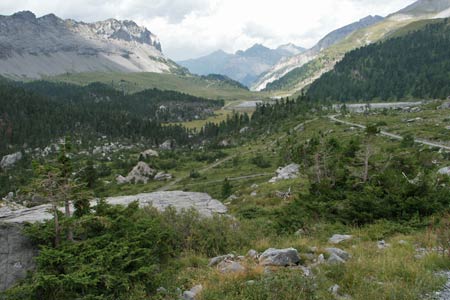
A circular walk that explores the valley above Sunnbüel. The route offers easy walking with some fine mountain views.
Start & End the upper station of the Luftseilbahn Kandersteg-Sunnbüel. See Transport Map for the Kandertal Region.
Exit the upper station of the Luftseilbahn Kandersteg-Sunnbüel and bear left to follow the main path signed to Schwarenbach. This descends slightly and crosses a broad valley dotted with small farms and other buildings. After Spittelmatte the path crosses the cantonal boundary and you enter Valais/Wallis.
Drawing level with the rocky, forested knoll of Arvenwald, there is a noticeable change to more barren scenery. Just as the track starts to climb up to Schwarenbach you reach a junction. Bear right here and turn west and then north following a path/track at the base of the Üschenegrat ridge, which is on your left. This leads back to the upper station of the cable car offering some fine views to the east.
Suggested Maps
 Landeskarte der Schweiz - 1:50000 - Sheet SW 5004 - Berner Oberland
Landeskarte der Schweiz - 1:50000 - Sheet SW5009 - Gstaad - Adelboden
Kandersteg Wanderkarte - 1:25000
Recommended Books
Alpine Flowers
 A pocket field guidebook for identifying 230 of the most commonly found alpine flowers of the Alps. Categorised by colour for quick identification, each alpine flower has a photograph and description of its key features. Flower names are given in English, French, German, Italian and Latin, with notes on curious facts and origins of names.
Across the Eastern Alps: E5
 From Lake Constance in Germany, this guidebook describes walking the E5 trek that runs 600km through a remarkable kaleidoscope of landscapes and culture in Switzerland, Austria and Italy, to its destination at Verona. It traverses the Allgauer, Lechtaler and Ötztaler Alps. There is a good network of alpine refuges and guesthouses on the route.
Stay Safe
Do enjoy yourself when out walking and choose a route that is within your capabilities especially with regard to navigation.
Do turn back if the weather deteriorates especially in winter or when visibility is poor.
Do wear the right clothing for the anticipated weather conditions. If the weather is likely to change for the worse make sure you have enough extra clothing in your pack.
Do tell someone where you are planning to walk especially in areas that see few other walkers.
Do take maps and other navigational aids. Do not rely on mobile devices in areas where reception is poor. Take spare batteries especially in cold weather.
Do check the weather forecast before leaving.
Do do not exceed your capabilities.
Please Note - These walks have been published for use by site visitors on the understanding that Walking Sitzerland is not held responsible for the safety or well being of those following the routes as described. It is worth reiterating the point that you should embark on a walk with the correct maps at the most detailed scale where possible. This will enable any difficulties with route finding to be assessed, and corrective action taken if necessary.