Kreuzboden - Almagelleralp - Saas Almagell Walk 8046
Canton - Valais / Wallis - Saastal
Author - Lou Johnson
Length - 10.0 km / 6.3 miles
Ascent - 160 metres / 528 feet
Descent - 900 metres / 2970 feet
Time - 4.50 hours
Grade - moderate
Click image to visit gallery of 15 images.
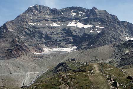
This walk includes a wonderful section of a balcony path high above the Saas Valley offering views to Saas Fee and the high mountains surrounding this mountain route. Take the Kreuzboden lift and exit the station. Continue to the path junction by the Hohsaas section of the gondola and follow the sign to Almagelleralp. The path continues under the cableway and crosses the hillside to head south. Initially the path follows the contours but soon rises gently across slopes that have many wild flowers in season - hence the name Alpenblumen Promenade. Below you can see the chapel in the hamlet of Trift.
Reaching a rocky area, the path continues with red and white waymarks helping you follow the route. The path starts to descend and turns around the Triftgrätji spur (2480m). From this point onwards the view changes with the Matmark Reservoir and Monte Moro Pass beyond now in view. The path descends past avalanche protection and continues to Almagelleralp. The walk so far has been dominated by wonderful views with most of the high mountains seen during the walk.
The path reaches a high point (2505m) at Wiessflue and it is from here that the final descent to the Almagellertal starts by a series of long zigzags to reach the Berghotel Almagelleralp (2194m). The path down to Saas Almagell is clear and well-marked offering an easy descent down to the valley floor. The zigzag route has several junctions but good signage makes it clear which route to choose. Nearing the valley floor the path splits with a choice of the upper or lower parts of Saas Almagell. If you intend to use the postbus service then follow the signs to the lower village (Unterer Dorfteil).
Suggested Maps
 Landeskarte der Schweiz - 1:50000 - Sheet SW 5006 - Matterhorn/Mischabel
Recommended Books
Walking in the Bernese Oberland
 This walking guidebook to the Bernese Oberland describes 113 day walks. Routes range from 2 to 24km and offer breathtaking scenery of the classic Eiger, Mönch and Jungfrau mountains, around Grindelwald, Lauterbrunnen, Gsteig and Meiringen. There are routes suitable for all abilities from short flat walks to adventurous treks.
Alpine Flowers
 A pocket field guidebook for identifying 230 of the most commonly found alpine flowers of the Alps. Categorised by colour for quick identification, each alpine flower has a photograph and description of its key features. Flower names are given in English, French, German, Italian and Latin, with notes on curious facts and origins of names.
Stay Safe
Do enjoy yourself when out walking and choose a route that is within your capabilities especially with regard to navigation.
Do turn back if the weather deteriorates especially in winter or when visibility is poor.
Do wear the right clothing for the anticipated weather conditions. If the weather is likely to change for the worse make sure you have enough extra clothing in your pack.
Do tell someone where you are planning to walk especially in areas that see few other walkers.
Do take maps and other navigational aids. Do not rely on mobile devices in areas where reception is poor. Take spare batteries especially in cold weather.
Do check the weather forecast before leaving.
Do do not exceed your capabilities.
Please Note - These walks have been published for use by site visitors on the understanding that Walking Sitzerland is not held responsible for the safety or well being of those following the routes as described. It is worth reiterating the point that you should embark on a walk with the correct maps at the most detailed scale where possible. This will enable any difficulties with route finding to be assessed, and corrective action taken if necessary.