Mattmarksee circuit Walk 8047
Canton - Valais / Wallis - Saastal
Author - Lou Johnson
Length - 8.0 km / 5 miles
Ascent - 120 metres / 396 feet
Descent - 120 metres / 396 feet
Time - 2.50 hours
Grade - easy
Click image to visit gallery of 5 images.
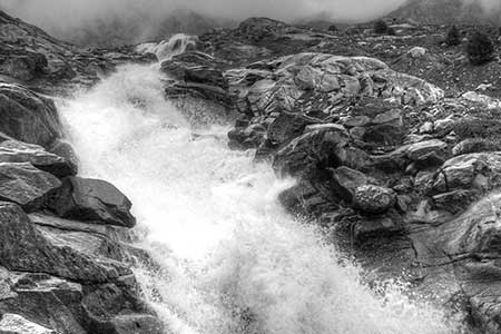
A circuit of Mattmarksee is ideal for those days when the cloud base is low and there is little point walking at higher elevations. However, it is probably a perfect place to walk in fine weather as you can really appreciate the rugged mountain scenery that encloses the reservoir.
The start is Mattmark dam, which is served by regular postbus services. There are toilets and refreshments here. From the road walk uphill to the dam wall. We chose to walk anti-clockwise around the reservoir and despite intermittent rain took our time and enjoyed the rocky, watery landscape. For the most part you are walking on a gravel track which for some reason seems more tiring than a true mountain path with its constant points of interest.
Suggested Maps
 Landeskarte der Schweiz - 1:50000 - Sheet SW 5006 - Matterhorn/Mischabel
Recommended Books
Across the Eastern Alps: E5
 From Lake Constance in Germany, this guidebook describes walking the E5 trek that runs 600km through a remarkable kaleidoscope of landscapes and culture in Switzerland, Austria and Italy, to its destination at Verona. It traverses the Allgauer, Lechtaler and Ötztaler Alps. There is a good network of alpine refuges and guesthouses on the route.
Walking in the Valais
 Comprehensive guidebook to the Valais region, describing 111 day walks and 10 multi-day tours. Home to the Matterhorn and Dent Blanche, the routes are in the Fieschertal and the Aletsch glacier region, the Lötschental, Saastal, Mattertal, Turtmanntal, Val d'Anniviers, Val d'Herens, Val de Bagnes, Val Ferret and Vallée du Trient.
Stay Safe
Do enjoy yourself when out walking and choose a route that is within your capabilities especially with regard to navigation.
Do turn back if the weather deteriorates especially in winter or when visibility is poor.
Do wear the right clothing for the anticipated weather conditions. If the weather is likely to change for the worse make sure you have enough extra clothing in your pack.
Do tell someone where you are planning to walk especially in areas that see few other walkers.
Do take maps and other navigational aids. Do not rely on mobile devices in areas where reception is poor. Take spare batteries especially in cold weather.
Do check the weather forecast before leaving.
Do do not exceed your capabilities.
Please Note - These walks have been published for use by site visitors on the understanding that Walking Sitzerland is not held responsible for the safety or well being of those following the routes as described. It is worth reiterating the point that you should embark on a walk with the correct maps at the most detailed scale where possible. This will enable any difficulties with route finding to be assessed, and corrective action taken if necessary.