Bernina Diavolezza - Bernina Ospizio Walk 8056
Canton - Graubunden/Grisons - Upper Engadine
Author - Lou Johnson
Length - 7.0 km / 4.4 miles
Ascent - 140 metres / 462 feet
Descent - nominal or unknown
Time - 2.00 hours
Grade - easy
Click image to visit gallery of 12 images.
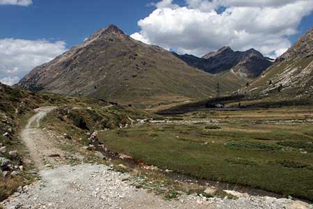
The Bernina Pass has always been one of my favourite landscapes. Barren and rocky with little to encourage farming its always seemed to be a wild place despite the increasing traffic on the road through the Pass. This route is an easy uphill walk allowing you to enjoy the landscape at your leisure. The start and end of the walk are served by regular trains on the Berninabahn from Pontresina to Tirano.
Alight at Bernina Diavolezza station (2093 m) and follow the clear track on the southwestern side of the railway that runs under the cables of the lift to Diavolezza. The way ahead is easy to follow and climbs gently with excellent views of the surrounding mountains. Continue past Bernina Lagalp station to reach Sur (2136 m). The onward path crosses the railway here as the track makes a large loop in order to lessen the gradient for uphill trains.
Re-crossing the railway the track continues to reach Lej Pitschen (which was completely dry in August). The track then skirts the western shores of Lej Nair which was reflecting the mountains in its surface. Soon after, after a short ascent, you reach Lago Bianco with its pale blue colour in complete contrast to Lej Nair. Turn left along the path around this large reservoir and continue to Bernina Ospizio station (2253 m). Note that there are no refreshments here.
You can continue along the shores of Lago Bianco and down to Alp Grüm by following walk 8055 to create a longer walk.
Suggested Maps
 Oberengadin, Bergell-Puschlav, Wanderkarte - 1:50000
Recommended Books
100 Hut Walks in the Alps
 This guidebook has route descriptions for 100 day walks to suit alpine walkers of all abilities, with suggestions for some hut-to-hut tours. These routes take you through breathtaking scenery in the Maritime Alps, Julian Alps, Gran Paradiso, the Turnitzer Alps, Bernese Oberland, the Kitzbuheler Alps and the Dolomites of South Tirol.
Tour of the Jungfrau Region
 A guidebook to the Tour of the Jungfrau Region, a 111km trek from Schynige Platte to Wilderswil in 9-12 days through the Bernese Oberland under the Mönch, Eiger and Jungfrau, exploring both well-known and hidden valleys, surrounded by soaring peaks, glaciers, lakes and ridges. A good first Alpine trek with plenty of bad-weather alternatives.
Stay Safe
Do enjoy yourself when out walking and choose a route that is within your capabilities especially with regard to navigation.
Do turn back if the weather deteriorates especially in winter or when visibility is poor.
Do wear the right clothing for the anticipated weather conditions. If the weather is likely to change for the worse make sure you have enough extra clothing in your pack.
Do tell someone where you are planning to walk especially in areas that see few other walkers.
Do take maps and other navigational aids. Do not rely on mobile devices in areas where reception is poor. Take spare batteries especially in cold weather.
Do check the weather forecast before leaving.
Do do not exceed your capabilities.
Please Note - These walks have been published for use by site visitors on the understanding that Walking Sitzerland is not held responsible for the safety or well being of those following the routes as described. It is worth reiterating the point that you should embark on a walk with the correct maps at the most detailed scale where possible. This will enable any difficulties with route finding to be assessed, and corrective action taken if necessary.