Murtel - Fuorcla Surlej Walk 8057
Canton - Graubunden/Grisons - Upper Engadine
Author - Lou Johnson
Length - 2.5 km / 1.6 miles
Ascent - 80 metres / 264 feet
Descent - 25 metres / 83 feet
Time - 1.25 hours
Grade - easy
Click image to visit gallery of 12 images.
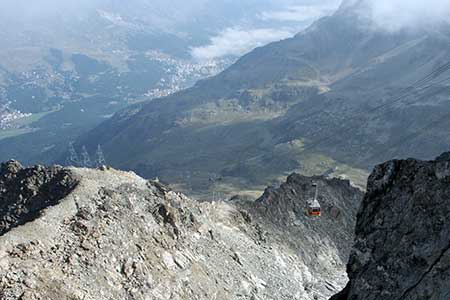
A short walk through the rocky landscape beneath the northern face of Corvatsch. The route is easy to follow, offers superb views down to Silvaplana and provides a real mountain experience. The start is the Murtel station of the Corvatsch cable-car which starts in Surlej. Buses provide regular connections with other parts of the area.
Exit Murtel station (2699 m) and take the signed path to Fuorcla Surlej with its refuge located in a superb position offering a wonderful mountain panorama especially to the south-east. The path is clear and obvious and you soon enter a rock strewn landscape with views to your left down towards Silvaplana and the valley some 900 metres below with its string of lakes shining in the sun. The walking is never difficult despite the terrain and quick progress is made to reach a path junction (2685 m) where the path comes up from the valley.
Turn right uphill following a series of zig-zags to a col from where a short descent leads you to the refuge at Fuorcla Surlej with its small lake offering a perfect place to sit and digest the view. The options are (a) return to Murtel station using the outward route, (b) continue on the direct path down to Val Roseg and onto Pontresina or (c) to continue south up the valley to the Coaz Hütte.
Suggested Maps
 Oberengadin, Bergell-Puschlav, Wanderkarte - 1:50000
Recommended Books
Tour of the Matterhorn
 A guide to the 145km Tour of the Matterhorn, described anti-clockwise from Zermatt and visits 6 valleys via Zinal, Arolla and Breuil, offering spectacular views of 25 peaks of over 4000m. The route also links up with the Chamonix to Zermatt walkers' Haute Route and the Tour of Monte Rosa. Includes two glacier crossings and takes 8 to 10 days.
Walking in the Alps
 An outstanding and comprehensive book exploring the walking and trekking possibilities in every Alpine region. Many thousands of possible routes are suggested, from the Maritime Alps of southern France throughout the range to the Julian Alps of Slovenia. Walks vary from undemanding to long and tough, and everything in between.
Stay Safe
Do enjoy yourself when out walking and choose a route that is within your capabilities especially with regard to navigation.
Do turn back if the weather deteriorates especially in winter or when visibility is poor.
Do wear the right clothing for the anticipated weather conditions. If the weather is likely to change for the worse make sure you have enough extra clothing in your pack.
Do tell someone where you are planning to walk especially in areas that see few other walkers.
Do take maps and other navigational aids. Do not rely on mobile devices in areas where reception is poor. Take spare batteries especially in cold weather.
Do check the weather forecast before leaving.
Do do not exceed your capabilities.
Please Note - These walks have been published for use by site visitors on the understanding that Walking Sitzerland is not held responsible for the safety or well being of those following the routes as described. It is worth reiterating the point that you should embark on a walk with the correct maps at the most detailed scale where possible. This will enable any difficulties with route finding to be assessed, and corrective action taken if necessary.