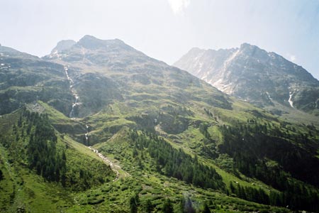
Val Roseg from PontresinaWalk 8116
Canton - Graubunden/Grisons - Upper Engadine
Author - Peter Smyly
Length - 27.0 km / 16.9 miles
Ascent - nominal or unknown
Descent - nominal or unknown
Grade - moderate/hard
Click image to visit gallery of 6 images.
Although no mountain summits are included in this walk, this is a walking route to the south west of Pontresina that spans around seventeen miles and which takes you into the heart of the mountains. With the right weather conditions, you are guaranteed to see some stunning landscape scenery, including glaciers, towering rocky peaks, waterfalls, a rushing glacial river, coniferous forests and a large glacial lake at the head of the valley, the Lej da Vadret, located in the upper Roseg Valley and overlooked by snowy peaks interspersed with glaciers or large ice sheets.
The walk has the advantage that, if you are staying in Pontresina, the start and finish points are right on your doorstep with no need for transport. It is a seven mile walk each way from Pontresina to the lake and back with an extra three miles added with a fairly steep ascent up onto a path that runs along a "balcony" about half way up the mountain before descending to return to the trail back down the valley. There is a hotel and bar serving refreshments a few miles up the valley, the Hotel Restaurant Roseg Gletscher', which can be reached by horse-drawn carriage The route offers no difficulties from a route-finding point of view, though as always, its sensible to take a map and compass and know how to use them in case of any unforeseen difficulties. Some people may be content to do the "there and back" to the lake section, makes for a decent length of walk in itself without the extra leg work involved in the additional ascent.
Start at Pontresina and the walk to the lake involves following a clear path by a fast-flowing milky-turquoise river along the Val Roseg, the Roseg Valley, backed by green coniferous forests and with towering mountains either side. The path does steepen a little on the approach to the lake which is a large expanse of water and milky-turquoise in appearance due to silt brought down from streams above. The valley also widens and the path departs from the river as progress is made along the valley. As the terrain becomes rockier and steeper at one point, wooden planks provide access across a torrent issuing down from the right.
This route suggests doing the extra loop. A clear path borders the lake to the right and then another path part way along the shore leads upwards. A way leads from here to a mountain hut at the head of the valley, but that is not included on this route; instead, the necessary height having been gained, another path heads back towards Pontresina, running more or less parallel to the valley path, out of sight below, but with a view that offers a wider perspective due to being higher up, the lake below now looking a long way down. The backdrop to the lake is dominated by snowy and rocky peaks with glacier. There is one potentially awkward section where it is necessary to cross a fairly wide stream and a certain amount of agility is required in stone-hopping, though fellow walkers with walking poles may be of assistance here too. Once you are back down at the hotel in the main valley, the route back is entirely straightforward as you follow the main path ahead in reversing this particular part of the route back to the starting point.
Suggested Maps
 Landeskarte der Schweiz - 1:50000 - Sheet SW 5013 - Oberengadin - Engiadin'Ota
Landeskarte der Schweiz - 1:25000 - Sheet SW 2521 - Engadin
Oberengadin, Bergell-Puschlav, Wanderkarte - 1:50000
Recommended Books
Alpine Flowers
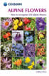 A pocket field guidebook for identifying 230 of the most commonly found alpine flowers of the Alps. Categorised by colour for quick identification, each alpine flower has a photograph and description of its key features. Flower names are given in English, French, German, Italian and Latin, with notes on curious facts and origins of names.
Walking in the Bernese Oberland
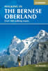 This walking guidebook to the Bernese Oberland describes 113 day walks. Routes range from 2 to 24km and offer breathtaking scenery of the classic Eiger, Mönch and Jungfrau mountains, around Grindelwald, Lauterbrunnen, Gsteig and Meiringen. There are routes suitable for all abilities from short flat walks to adventurous treks.
Stay Safe
Do enjoy yourself when out walking and choose a route that is within your capabilities especially with regard to navigation.
Do turn back if the weather deteriorates especially in winter or when visibility is poor.
Do wear the right clothing for the anticipated weather conditions. If the weather is likely to change for the worse make sure you have enough extra clothing in your pack.
Do tell someone where you are planning to walk especially in areas that see few other walkers.
Do take maps and other navigational aids. Do not rely on mobile devices in areas where reception is poor. Take spare batteries especially in cold weather.
Do check the weather forecast before leaving.
Do do not exceed your capabilities.
Please Note - These walks have been published for use by site visitors on the understanding that Walking Sitzerland is not held responsible for the safety or well being of those following the routes as described. It is worth reiterating the point that you should embark on a walk with the correct maps at the most detailed scale where possible. This will enable any difficulties with route finding to be assessed, and corrective action taken if necessary.