Muottas Muragl - Lej Muragl - Muottas MuraglWalk 8013
Canton - Graubunden/Grisons - Upper Engadine
Author - Lou Johnson
Length - 7.0 km / 4.4 miles
Ascent - 340 metres / 1122 feet
Descent - 340 metres / 1122 feet
Time - 2.50 hours
Grade - easy/moderate
Click image to visit gallery of 6 images.
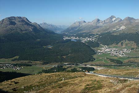
This walk provides a good introduction to the area providing a grandstand view of the Upper Engadine. In addition it takes you away from the crowds and allows you to enjoy the tranquil setting of a lake set amidst the mountains. Note the only point on the walk where refreshments are available is the start/end point of the walk.
Start & End - Mountain station of the Muottas Muragl funicular. The valley station is Punt Muragl which is served by rail and bus services from Pontresina, St. Moritz, Celerina and Samedan. The funicular also benefits from evening services so this high level walk can be completed at sunset without fear of being stranded on the mountain. See Transport Map for the Upper Engadine Region.
Exit the mountain station of the funicular and follow the main path east. After a short way take the left fork signed to Lej Muragl. Starting as a ski track the route narrows and becomes a path traversing the southern slopes of a rocky ridge. The ascent is steady and you can keep going at a good pace. Reaching a path junction turn right and descend to the shores of the lake - Lej Muragl.
It is a wonderful situation with mountains rising steeply from the shores and the perfect place to spend some time. Those who have set off early will probably have the shores to themselves and be able to enjoy the peaceful setting at its best. After enjoying the beauty of the location follow the western shore of the lake and locate the path that follows the exit stream down into the valley. The going is easy with excellent views ahead.
After about 30 minutes walk from the lake you will find yourself following the ridge of an old moraine, evidence of the recent glacial past of this whole region. Reaching a major junction of paths at a small footbridge turn right and continue uphill back to the start.
Suggested Maps
 Landeskarte der Schweiz - 1:50000 - Sheet SW 5013 - Oberengadin - Engiadin'Ota
Landeskarte der Schweiz - 1:25000 - Sheet SW 2521 - Engadin
Oberengadin, Bergell-Puschlav, Wanderkarte - 1:50000
Recommended Books
Walking in the Alps
 An outstanding and comprehensive book exploring the walking and trekking possibilities in every Alpine region. Many thousands of possible routes are suggested, from the Maritime Alps of southern France throughout the range to the Julian Alps of Slovenia. Walks vary from undemanding to long and tough, and everything in between.
Walking in the Bernese Oberland
 This walking guidebook to the Bernese Oberland describes 113 day walks. Routes range from 2 to 24km and offer breathtaking scenery of the classic Eiger, Mönch and Jungfrau mountains, around Grindelwald, Lauterbrunnen, Gsteig and Meiringen. There are routes suitable for all abilities from short flat walks to adventurous treks.
Stay Safe
Do enjoy yourself when out walking and choose a route that is within your capabilities especially with regard to navigation.
Do turn back if the weather deteriorates especially in winter or when visibility is poor.
Do wear the right clothing for the anticipated weather conditions. If the weather is likely to change for the worse make sure you have enough extra clothing in your pack.
Do tell someone where you are planning to walk especially in areas that see few other walkers.
Do take maps and other navigational aids. Do not rely on mobile devices in areas where reception is poor. Take spare batteries especially in cold weather.
Do check the weather forecast before leaving.
Do do not exceed your capabilities.
Please Note - These walks have been published for use by site visitors on the understanding that Walking Sitzerland is not held responsible for the safety or well being of those following the routes as described. It is worth reiterating the point that you should embark on a walk with the correct maps at the most detailed scale where possible. This will enable any difficulties with route finding to be assessed, and corrective action taken if necessary.