Corviglia - Pass SuvrettaWalk 8015
Canton - Graubunden/Grisons - Upper Engadine
Author - Lou Johnson
Length - 5.0 km / 3.1 miles
Ascent - 240 metres / 792 feet
Descent - 100 metres / 330 feet
Time - 1.50 hours
Grade - easy/moderate
Click image to visit gallery of 6 images.
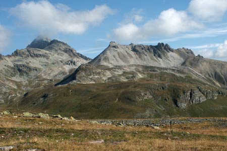
Being a popular skiing area, Corviglia does suffer from some visual pollution from the many ski-lifts and other infrastructure constructed in recent years. However as the walk progresses the visual impacts fade and you enter a wild a wonderful pass with mountains forming a beautiful backdrop.
Start - The upper station of the Corviglia Funicular, which offers connections to St Moritz with its many train and bus routes. Alternatively you can use the cableways that ascend from the valley at Celerina. See Transport Map for the Upper Engadine Region.
End - Pass Suvretta where you can continue by following Walk 016 or return by the same route. Other options include a return over the summit of Piz Nair or a descent to Champfer in the valley.
From the upper station of the Corviglia funicular follow the signs to Pass Suvretta. Initially the route follows rough tracks in a northwesterly direction climbing steeply for a short way. The Piz Nair cable car is to your left. At the first signed junction go left to continue along a track (Note - in 2003 this was poorly signed and in places the path was severely disrupted due to construction work). The path goes beneath the Piz Nair cable car with excellent view across the Upper Engadine valley to Piz Bernina.
Maintaining a steady height across the mountainside the track reaches the upper station of the Signalbahn chairlift. Shortly afterwards a well-signed path leaves the track. To your right the rocky slopes of Piz Nair rise steeply. Ahead shapely Piz Julier with its small glacier looks very spectacular. Go straight ahead at the next junction where a path goes right to the summit of Piz Nair.
The scenery is now in complete contrast to the start of the walk with natural scenic beauty uninterrupted by modern construction work. The path is interesting weaving through rocky terrain. Lej Suvretta, still unseen, lies ahead.
Rounding a rocky bluff, Lej Suvretta comes into view. Its waters adding sparkle to the mountain scenery. The path descends to Suvretta Pass (2615 m.) with signs providing assistance for onward routes.
Suggested Maps
 Landeskarte der Schweiz - 1:50000 - Sheet SW 5013 - Oberengadin - Engiadin'Ota
Landeskarte der Schweiz - 1:25000 - Sheet SW 2521 - Engadin
Oberengadin, Bergell-Puschlav, Wanderkarte - 1:50000
Recommended Books
Trekking in the Silvretta and Rätikon Alps
 This guide describes three treks, between 5 and 8 days, in the Silvretta and Rätikon Alps starting near Klosters, and 12 half-day hut-to-hut routes. These contrasting ranges form a line on the borders of Switzerland, Austria and Liechtenstein. The Tour of the Silvretta, the Prättigauer Höhenweg and the Rätikon Höhenweg.
Walking in the Alps
 An outstanding and comprehensive book exploring the walking and trekking possibilities in every Alpine region. Many thousands of possible routes are suggested, from the Maritime Alps of southern France throughout the range to the Julian Alps of Slovenia. Walks vary from undemanding to long and tough, and everything in between.
Stay Safe
Do enjoy yourself when out walking and choose a route that is within your capabilities especially with regard to navigation.
Do turn back if the weather deteriorates especially in winter or when visibility is poor.
Do wear the right clothing for the anticipated weather conditions. If the weather is likely to change for the worse make sure you have enough extra clothing in your pack.
Do tell someone where you are planning to walk especially in areas that see few other walkers.
Do take maps and other navigational aids. Do not rely on mobile devices in areas where reception is poor. Take spare batteries especially in cold weather.
Do check the weather forecast before leaving.
Do do not exceed your capabilities.
Please Note - These walks have been published for use by site visitors on the understanding that Walking Sitzerland is not held responsible for the safety or well being of those following the routes as described. It is worth reiterating the point that you should embark on a walk with the correct maps at the most detailed scale where possible. This will enable any difficulties with route finding to be assessed, and corrective action taken if necessary.