Pass Suvretta - Alp SuvrettaWalk 8016
Canton - Graubunden/Grisons - Upper Engadine
Author - Lou Johnson
Length - 5.0 km / 3.1 miles
Ascent - nominal or unknown
Descent - 470 metres / 1551 feet
Time - 1.50 hours
Grade - easy/moderate
Click image to visit gallery of 9 images.
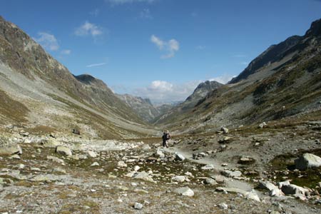
This route is a classic valley walk that benefits from a sense of wilderness. Downhill all the way, it might suffer from some difficulties after prolonged rain as there are a number of places where the path crosses a stream without provision of bridges.
Start - Pass Suvretta. No mechanical means of reaching here from the valley. Walk 8015 provides a very pleasant approach.
End - Alp Suvretta. The only way out is on foot by following Walk 8017 or returning by the same route.
From Pass Suvretta head north following the signed path to Spinas. The path immediately starts its descent through a wild and stony section. Descending further the path crosses a wide but shallow stream to reach drier ground. In wet weather this section may provide some difficulties.
Continuing north you will probably hear whistles from the many Marmot colonies in the valley. After about 50 minutes the path suddenly steepens and descends with zig-zags into Val Bever. Below lies the isolated summer farm of Alp Suvretta where there is the possibility to purchase milk and yoghurt.
To continue this route follow Walk 8017.
Suggested Maps
 Landeskarte der Schweiz - 1:50000 - Sheet SW 5013 - Oberengadin - Engiadin'Ota
Landeskarte der Schweiz - 1:25000 - Sheet SW 2521 - Engadin
Oberengadin, Bergell-Puschlav, Wanderkarte - 1:50000
Recommended Books
Tour of the Jungfrau Region
 A guidebook to the Tour of the Jungfrau Region, a 111km trek from Schynige Platte to Wilderswil in 9-12 days through the Bernese Oberland under the Mönch, Eiger and Jungfrau, exploring both well-known and hidden valleys, surrounded by soaring peaks, glaciers, lakes and ridges. A good first Alpine trek with plenty of bad-weather alternatives.
Trekking in the Alps
 A book to 20 classic trekking routes in the Alps. Exploring the best trekking areas, outline descriptions and photographs illustrate the classics such as the Tour of Mont Blanc, and Chamonix to Zermatt, as well a number of trekking routes in Slovenia, the Italian Dolomites, the French Alps, Austrian Alps and Swiss Alps. Ideal for inspiration.
Stay Safe
Do enjoy yourself when out walking and choose a route that is within your capabilities especially with regard to navigation.
Do turn back if the weather deteriorates especially in winter or when visibility is poor.
Do wear the right clothing for the anticipated weather conditions. If the weather is likely to change for the worse make sure you have enough extra clothing in your pack.
Do tell someone where you are planning to walk especially in areas that see few other walkers.
Do take maps and other navigational aids. Do not rely on mobile devices in areas where reception is poor. Take spare batteries especially in cold weather.
Do check the weather forecast before leaving.
Do do not exceed your capabilities.
Please Note - These walks have been published for use by site visitors on the understanding that Walking Sitzerland is not held responsible for the safety or well being of those following the routes as described. It is worth reiterating the point that you should embark on a walk with the correct maps at the most detailed scale where possible. This will enable any difficulties with route finding to be assessed, and corrective action taken if necessary.