Morterasch GlacierWalk 8021
Canton - Graubunden/Grisons - Upper Engadine
Author - Lou Johnson
Length - 6.0 km / 3.8 miles
Ascent - 80 metres / 264 feet
Descent - 80 metres / 264 feet
Time - 2.00 hours
Grade - easy
Click image to visit gallery image.
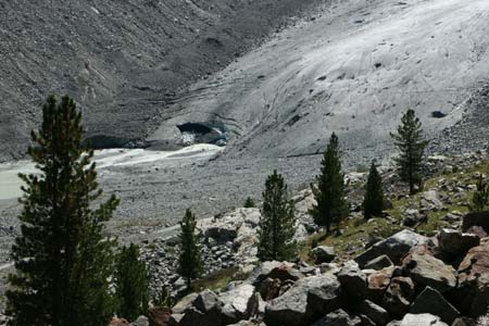
An easy walk that is full of interest. There are signs explaining how the glacier has retreated in recent years with markers showing the location of the toe of the glacier for each of the key years. The text is in German but the broad picture can be easily understood from the diagrams.
Start & End - Morterasch station on the Bernina Railway. Trains operate from Pontresina to Alp Grüm with connections from other parts of the Engadine. See Transport Map for the Upper Engadine Region.
Leave the railway station and take the broad track that goes south to the foot of the Morterasch Glacier. You are unlikely to walk alone especially after the arrival of a train as this is a popular walk.
There are no navigational problems. All you need to do is walk along the clear path in the floor of the valley. The glacier gradually gets nearer and you are able to reach and touch the ice! The valley is very scenic and there are plenty of places to sit and enjoy the view.
Once you have seen enough, turn back and head the way you came. For those with energy to spare you can return by a different route. This path climbs up to the crest of the moraine and then drops back down to Morterasch through pleasant forest.
Suggested Maps
 Landeskarte der Schweiz - 1:50000 - Sheet SW 5013 - Oberengadin - Engiadin'Ota
Landeskarte der Schweiz - 1:25000 - Sheet SW 2521 - Engadin
Oberengadin, Bergell-Puschlav, Wanderkarte - 1:50000
Recommended Books
Walks in the Engadine - Switzerland
 A walking guidebook to 100 day walks in the Engadine, Val Bregaglia, neighbouring valleys and the Engadine National Park. Varying from gentle rambles to adventurous high-level routes for the experienced mountain walker. Each route ranges from 2 to 10 miles long, visiting forests and meadows, high mountain landscapes, lakes and passes.
Tour of Monte Rosa
 A guidebook to walking the The Tour of Monte Rosa, a 9-10 day, 134km trek circling Monte Rosa anti-clockwise from Zermatt. The high route hugs glaciers and has views of over ten 4000ers. All essential information is provided, including outline maps, route profiles, advice on glacier crossing and accommodation.
Stay Safe
Do enjoy yourself when out walking and choose a route that is within your capabilities especially with regard to navigation.
Do turn back if the weather deteriorates especially in winter or when visibility is poor.
Do wear the right clothing for the anticipated weather conditions. If the weather is likely to change for the worse make sure you have enough extra clothing in your pack.
Do tell someone where you are planning to walk especially in areas that see few other walkers.
Do take maps and other navigational aids. Do not rely on mobile devices in areas where reception is poor. Take spare batteries especially in cold weather.
Do check the weather forecast before leaving.
Do do not exceed your capabilities.
Please Note - These walks have been published for use by site visitors on the understanding that Walking Sitzerland is not held responsible for the safety or well being of those following the routes as described. It is worth reiterating the point that you should embark on a walk with the correct maps at the most detailed scale where possible. This will enable any difficulties with route finding to be assessed, and corrective action taken if necessary.