Eggeschwand - Kander Waterfalls - Waldhaus - EggeschwandWalk 8036
Canton - Bern / Berne - Kandertal
Author - Lou Johnson
Length - 5.0 km / 3.1 miles
Ascent - 165 metres / 545 feet
Descent - 165 metres / 545 feet
Time - 2.50 hours
Grade - easy/moderate
Click image to visit gallery of 3 images.
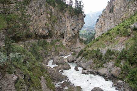
This walk climbs through a dramatic ravine occupied by the River Kander. In spate the waterfalls are very impressive. Retrospective views to Kandersteg can also be enjoyed. The return route follows the road cut into the rocks above the falls.
Start the valley station of the Luftseilbahn Kandersteg-Sunnbüel. See Transport Map for the Kandertal Region.
End the Berghotel Waldhaus. Please note the bus service is limited and reservations are recommended. Current information can be obtained from the Tourist Information Bureau in Kandersteg. The bus stop is a few minutes walk from the Berghotel on the main valley road.
From the rear of the car park for the Kandersteg-Sunnbüel cable car, take the signed footpath to Waldhaus via the gorge (klus). The path climbs through the gorge with the river on your right before climbing up to the road that serves the upper valley as far as Selden. After a short way along the road drop down and cross the river by the footbridge and continue upstream as far as the road bridge.
The trail then continues to the Berghotel Waldhaus where refreshments are available. The return route is to take the broad track from the hotel back to the valley road. Turn left and follow the road over the bridge, through the tunnels (taking care with traffic). The road descends to reach the main road. For pedestrians there is a short cut footpath on the right that descends to the main road. On reaching the main valley road, turn right. The valley cable car station is on your right after approximately 300 metres.
Suggested Maps
 Landeskarte der Schweiz - 1:50000 - Sheet SW 5004 - Berner Oberland
Landeskarte der Schweiz - 1:50000 - Sheet SW5009 - Gstaad - Adelboden
Kandersteg Wanderkarte - 1:25000
Recommended Books
Tour of the Jungfrau Region
 A guidebook to the Tour of the Jungfrau Region, a 111km trek from Schynige Platte to Wilderswil in 9-12 days through the Bernese Oberland under the Mönch, Eiger and Jungfrau, exploring both well-known and hidden valleys, surrounded by soaring peaks, glaciers, lakes and ridges. A good first Alpine trek with plenty of bad-weather alternatives.
The Swiss Alpine Pass Route - Via Alpina Route 1
 Guidebook to the Alpine Pass Route following the Swiss Via Alpina 1, a 360km trek east-west across Switzerland, from Sargans, on the border of Liechtenstein, to Montreux, including prologue from Liechtenstein. A demanding 3-week trek described in 18 stages, crossing 16 passes including the 2778m Hohtürli. Requires good fitness and experience.
Stay Safe
Do enjoy yourself when out walking and choose a route that is within your capabilities especially with regard to navigation.
Do turn back if the weather deteriorates especially in winter or when visibility is poor.
Do wear the right clothing for the anticipated weather conditions. If the weather is likely to change for the worse make sure you have enough extra clothing in your pack.
Do tell someone where you are planning to walk especially in areas that see few other walkers.
Do take maps and other navigational aids. Do not rely on mobile devices in areas where reception is poor. Take spare batteries especially in cold weather.
Do check the weather forecast before leaving.
Do do not exceed your capabilities.
Please Note - These walks have been published for use by site visitors on the understanding that Walking Sitzerland is not held responsible for the safety or well being of those following the routes as described. It is worth reiterating the point that you should embark on a walk with the correct maps at the most detailed scale where possible. This will enable any difficulties with route finding to be assessed, and corrective action taken if necessary.