Waldhaus - SeldenWalk 8037
Canton - Bern / Berne - Kandertal
Author - Lou Johnson
Length - 6.0 km / 3.8 miles
Ascent - 190 metres / 627 feet
Descent - nominal or unknown
Time - 1.50 hours
Grade - easy
Click image to visit gallery of 3 images.
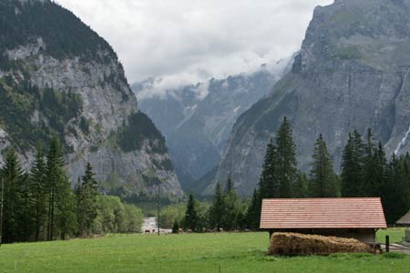
A peaceful valley walk following the River Kander upstream from the Berghotel Waldhaus to the Hotel Gasterntal at Selden. The surrounding mountains offer a continuous and dramatic backdrop throughout the walk.
Start the Berghotel Waldhaus. See Transport Map for the Kandertal Region. Please note the bus service is limited and reservations are recommended. Current information can be obtained from the Tourist Information Bureau in Kandersteg. If taking the bus you will be dropped off at the end of the road leading to the Waldhaus from the valley service road.
End the Hotel Gasterntal, Selden
From the Waldhaus follow the broad path/track up the valley signed to Selden and the Balmhornhütte. The path to the latter branches off right after one kilometre and you should continue up the track to reach a bridge over the River Kander. Cross the bridge and turn right on the other side. The path follows the river up to another bridge. Cross the river again and continue through forest.
Crossing the river for a final time, you reach the foot of a step in the valley floor. The path climbs in zigzags to enter a hanging valley. Quite soon the path joins the valley service road. Continue along this to the Hotel Gasternal from where the bus service back to Kandersteg departs.
Suggested Maps
 Landeskarte der Schweiz - 1:50000 - Sheet SW 5004 - Berner Oberland
Landeskarte der Schweiz - 1:50000 - Sheet SW5009 - Gstaad - Adelboden
Kandersteg Wanderkarte - 1:25000
Recommended Books
Tour of Monte Rosa
 A guidebook to walking the The Tour of Monte Rosa, a 9-10 day, 134km trek circling Monte Rosa anti-clockwise from Zermatt. The high route hugs glaciers and has views of over ten 4000ers. All essential information is provided, including outline maps, route profiles, advice on glacier crossing and accommodation.
Trekking in the Alps
 A book to 20 classic trekking routes in the Alps. Exploring the best trekking areas, outline descriptions and photographs illustrate the classics such as the Tour of Mont Blanc, and Chamonix to Zermatt, as well a number of trekking routes in Slovenia, the Italian Dolomites, the French Alps, Austrian Alps and Swiss Alps. Ideal for inspiration.
Stay Safe
Do enjoy yourself when out walking and choose a route that is within your capabilities especially with regard to navigation.
Do turn back if the weather deteriorates especially in winter or when visibility is poor.
Do wear the right clothing for the anticipated weather conditions. If the weather is likely to change for the worse make sure you have enough extra clothing in your pack.
Do tell someone where you are planning to walk especially in areas that see few other walkers.
Do take maps and other navigational aids. Do not rely on mobile devices in areas where reception is poor. Take spare batteries especially in cold weather.
Do check the weather forecast before leaving.
Do do not exceed your capabilities.
Please Note - These walks have been published for use by site visitors on the understanding that Walking Sitzerland is not held responsible for the safety or well being of those following the routes as described. It is worth reiterating the point that you should embark on a walk with the correct maps at the most detailed scale where possible. This will enable any difficulties with route finding to be assessed, and corrective action taken if necessary.