Allmenalp - FirstWalk 8044
Canton - Bern / Berne - Kandertal
Author - Lou Johnson
Length - 3.0 km / 1.9 miles
Ascent - 820 metres / 2706 feet
Descent - nominal or unknown
Time - 2.00 hours
Grade - moderate
Click image to visit gallery of 6 images.
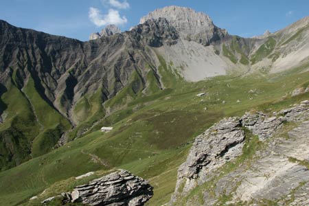
A wonderful mountain walk to the dramatic summit of First, which is located on a steep sided ridge high above Kandersteg. The summit offers some excellent views and needs a head for heights.
Start The upper station of the Allmenalp cable car. The valley station is ten minutes walk from Kandersteg railway station. Regular trains from Spiez (with connections from Interlaken) and Brig. Also bus service from Frutigen. See Transport Map for the Kandertal Region.
End the summit of First (2549m)
Exit the upper station of the Allmenalp cable car and consult the extensive array of signs. As you will discover the onward route takes you uphill towards the farm of Obere Allme. Just before reaching this there is a path junction where you turn right to start an interesting ascent. At first the path traverses grassy slopes but as you climb the amount of exposed rock increases.
Reaching a building at Steintal you follow the path round the back of the building and then start a section of steeper ascent. Like most similar paths in Switzerland, well constructed zigzags make the going fairly easy and quite soon you reach the crest of the Allmegrat ridge. The summit of First is a short way along the ridge and offers some superb views.
To continue this route follow Walk 8045.
Suggested Maps
 Landeskarte der Schweiz - 1:50000 - Sheet SW 5004 - Berner Oberland
Landeskarte der Schweiz - 1:50000 - Sheet SW5009 - Gstaad - Adelboden
Kandersteg Wanderkarte - 1:25000
Recommended Books
The Tour of the Bernina
 Guidebook describing a 9-stage (119km) route around the Piz Bernina massif in the Alps on the Swiss-Italian border near St Moritz, and the 8-stage (94km) Alta Via Valmalenco exploring the Valmalenco valley, in the shadow of Monte Disgrazia. The Tour of the Bernina is suitable for first-time trekkers but the Alta Via needs some experience.
100 Hut Walks in the Alps
 This guidebook has route descriptions for 100 day walks to suit alpine walkers of all abilities, with suggestions for some hut-to-hut tours. These routes take you through breathtaking scenery in the Maritime Alps, Julian Alps, Gran Paradiso, the Turnitzer Alps, Bernese Oberland, the Kitzbuheler Alps and the Dolomites of South Tirol.
Stay Safe
Do enjoy yourself when out walking and choose a route that is within your capabilities especially with regard to navigation.
Do turn back if the weather deteriorates especially in winter or when visibility is poor.
Do wear the right clothing for the anticipated weather conditions. If the weather is likely to change for the worse make sure you have enough extra clothing in your pack.
Do tell someone where you are planning to walk especially in areas that see few other walkers.
Do take maps and other navigational aids. Do not rely on mobile devices in areas where reception is poor. Take spare batteries especially in cold weather.
Do check the weather forecast before leaving.
Do do not exceed your capabilities.
Please Note - These walks have been published for use by site visitors on the understanding that Walking Sitzerland is not held responsible for the safety or well being of those following the routes as described. It is worth reiterating the point that you should embark on a walk with the correct maps at the most detailed scale where possible. This will enable any difficulties with route finding to be assessed, and corrective action taken if necessary.