Furggstalden - Furgg Valley (Furggtälli) Walk 8053
Canton - Valais / Wallis - Saastal
Author - Lou Johnson
Length - 11.0 km / 6.9 miles
Ascent - 400 metres / 1320 feet
Descent - 400 metres / 1320 feet
Time - 4.00 hours
Grade - easy/moderate
Click image to visit gallery of 6 images.
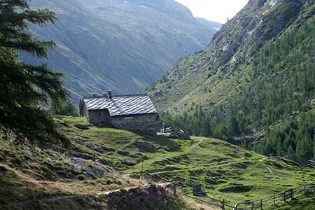
This is a wonderful walk into the Furgg Valley, a hanging valley, lying southeast of Saas Almagell. The valley offers glorious mountain scenery, solitude, and a good chance to see wildlife. The walking is along goof paths with a gentle ascent into the valley.
From Saas Almagell take the gondola life to Furggstalden. A journey time of about 4 minutes saves 230 metres of ascent through forest. Reaching the top of the lift and two nearby restaurants. Follow the signs into the Furggtälli across meadows towards the valley. Continue past the buildings at Furggalp. Initially there are paths either side of the Furggbach river. We chose the path on the north bank of the river and continues upstream into the valley.
The path is easy to follow with a gentle gradient and takes you into a beautiful valley. On the day we completed the walk we saw no-one else and had the beautiful mountain landscape all to ourselves. We continue upstream until the path on the south side came in from the right (2302 m.). We continued ahead for another 30 minutes and had a picnic lunch. Apart from the rushing stream, we enjoyed complete silence and were lucky to see Ibex while we ate.
To return to the start either retrace your route or, for some variety, follow the path on the south of the river. If you take this option continue downstream to cross a bridge near the buildings at Furggalp. All that remains is a pleasant stroll across meadows back to the lift and a descent on the gondola down to Saas Almagell.
Suggested Maps
 Landeskarte der Schweiz - 1:50000 - Sheet SW 5006 - Matterhorn/Mischabel
Recommended Books
The Swiss Alpine Pass Route - Via Alpina Route 1
 Guidebook to the Alpine Pass Route following the Swiss Via Alpina 1, a 360km trek east-west across Switzerland, from Sargans, on the border of Liechtenstein, to Montreux, including prologue from Liechtenstein. A demanding 3-week trek described in 18 stages, crossing 16 passes including the 2778m Hohtürli. Requires good fitness and experience.
Tour of Monte Rosa
 A guidebook to walking the The Tour of Monte Rosa, a 9-10 day, 134km trek circling Monte Rosa anti-clockwise from Zermatt. The high route hugs glaciers and has views of over ten 4000ers. All essential information is provided, including outline maps, route profiles, advice on glacier crossing and accommodation.
Stay Safe
Do enjoy yourself when out walking and choose a route that is within your capabilities especially with regard to navigation.
Do turn back if the weather deteriorates especially in winter or when visibility is poor.
Do wear the right clothing for the anticipated weather conditions. If the weather is likely to change for the worse make sure you have enough extra clothing in your pack.
Do tell someone where you are planning to walk especially in areas that see few other walkers.
Do take maps and other navigational aids. Do not rely on mobile devices in areas where reception is poor. Take spare batteries especially in cold weather.
Do check the weather forecast before leaving.
Do do not exceed your capabilities.
Please Note - These walks have been published for use by site visitors on the understanding that Walking Sitzerland is not held responsible for the safety or well being of those following the routes as described. It is worth reiterating the point that you should embark on a walk with the correct maps at the most detailed scale where possible. This will enable any difficulties with route finding to be assessed, and corrective action taken if necessary.