Maloja - Sils Maria Walk 8069
Canton - Graubunden/Grisons - Upper Engadine
Author - Lou Johnson
Length - 6.2 km / 3.9 miles
Ascent - 20 metres / 66 feet
Descent - 20 metres / 66 feet
Time - 1.50 hours
Grade - easy
Click image to visit gallery image.
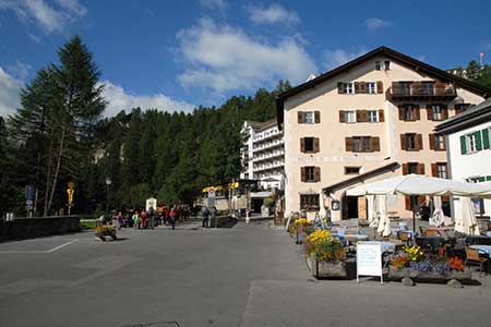
This is an easy walk that offers some fine mountain and lakeside panoramas. The start is the Post in Maloja where a regular bus service provides convenient links to other parts of the Upper Engadine. The end of the walk is the pretty village of Sils-Maria with its many shops, cafés and restaurants. Again there are regular connecting bus services with other towns and villages in the Upper Engadine.
To walk to Sils Maria continue along the main road and past the Schweitzerhaus Hotel. Immediately after take the signed footpath to Seglia Maria. This tarmac road leads towards a church. Follow the signs for Isola and red and white waymarks as you head towards the lake. Turn right at the lake and follow the path along the lakeshore past Isola and on to Sils Maria.
Suggested Maps
 Oberengadin, Bergell-Puschlav, Wanderkarte - 1:50000
Recommended Books
100 Hut Walks in the Alps
 This guidebook has route descriptions for 100 day walks to suit alpine walkers of all abilities, with suggestions for some hut-to-hut tours. These routes take you through breathtaking scenery in the Maritime Alps, Julian Alps, Gran Paradiso, the Turnitzer Alps, Bernese Oberland, the Kitzbuheler Alps and the Dolomites of South Tirol.
Tour of Monte Rosa
 A guidebook to walking the The Tour of Monte Rosa, a 9-10 day, 134km trek circling Monte Rosa anti-clockwise from Zermatt. The high route hugs glaciers and has views of over ten 4000ers. All essential information is provided, including outline maps, route profiles, advice on glacier crossing and accommodation.
Stay Safe
Do enjoy yourself when out walking and choose a route that is within your capabilities especially with regard to navigation.
Do turn back if the weather deteriorates especially in winter or when visibility is poor.
Do wear the right clothing for the anticipated weather conditions. If the weather is likely to change for the worse make sure you have enough extra clothing in your pack.
Do tell someone where you are planning to walk especially in areas that see few other walkers.
Do take maps and other navigational aids. Do not rely on mobile devices in areas where reception is poor. Take spare batteries especially in cold weather.
Do check the weather forecast before leaving.
Do do not exceed your capabilities.
Please Note - These walks have been published for use by site visitors on the understanding that Walking Sitzerland is not held responsible for the safety or well being of those following the routes as described. It is worth reiterating the point that you should embark on a walk with the correct maps at the most detailed scale where possible. This will enable any difficulties with route finding to be assessed, and corrective action taken if necessary.