Trient - Refuge Les Grands - Col de BalmeWalk 8105
Canton - Valais / Wallis - Vallee du Trient
Author - Trient Office de Tourisme
Length - 7.5 km / 4.7 miles
Ascent - 1160 metres / 3828 feet
Descent - 200 metres / 660 feet
Time - 4.50 hours
Grade - moderate
Click image to visit gallery of 3 images.
A hike to the Col de Balme that can be combined with walk 8103 or walk 8104 to provide a good full-day circuit.
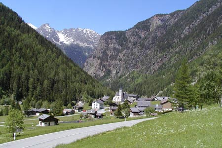
Start & End - the village of Trient, 10 km. southwest of Martigny (VS).
From the village church walk up to the main road. Turn right in the direction of Forclaz. After a short distance along the road, take the signed track on the left which directs you to the Sentier du Bisse-Glacier. This leads you uphill to reach the main road to Forclaz. Go straight across the road and onto the track/footpath.
Height is gained as you zig-zag upwards. Meeting the transverse path from Forclaz, turn right and follow the drainage channel (bisse) south towards the Glacier du Trient. Almost level the path threads through trees with occasional views across the valley to the Col de Balme.
You reach the Chalet du Glacier (1583 m.) where refreshments are available in season. A grand view of the Glacier can be enjoyed whilst you take a break. Backtrack a few metres and turn left to cross a footbridge. Reaching a further path junction turn left again and begin a steady climb through trees to reach another path junction. Turn left and continue climbing to reach a hanging valley with the Glacier des Grands above.
The path becomes steeper using zigzags to gain height with a section of fixed cable offering a safeguard on the most exposed section. Soon you reach the Refuge Les Grands. With most of the climb now complete the path undulates across the mountainside to enter the Nant Noir valley at high level. Turning southwest the path continues to the Col de Balme.
Suggested Maps
 Landeskarte der Schweiz - 1:50000 - Sheet SW 5003 - Mont Blanc - Grand Combin
Recommended Books
Tour of the Matterhorn
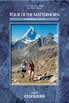 A guide to the 145km Tour of the Matterhorn, described anti-clockwise from Zermatt and visits 6 valleys via Zinal, Arolla and Breuil, offering spectacular views of 25 peaks of over 4000m. The route also links up with the Chamonix to Zermatt walkers' Haute Route and the Tour of Monte Rosa. Includes two glacier crossings and takes 8 to 10 days.
Trekking in the Alps
 A book to 20 classic trekking routes in the Alps. Exploring the best trekking areas, outline descriptions and photographs illustrate the classics such as the Tour of Mont Blanc, and Chamonix to Zermatt, as well a number of trekking routes in Slovenia, the Italian Dolomites, the French Alps, Austrian Alps and Swiss Alps. Ideal for inspiration.
Stay Safe
Do enjoy yourself when out walking and choose a route that is within your capabilities especially with regard to navigation.
Do turn back if the weather deteriorates especially in winter or when visibility is poor.
Do wear the right clothing for the anticipated weather conditions. If the weather is likely to change for the worse make sure you have enough extra clothing in your pack.
Do tell someone where you are planning to walk especially in areas that see few other walkers.
Do take maps and other navigational aids. Do not rely on mobile devices in areas where reception is poor. Take spare batteries especially in cold weather.
Do check the weather forecast before leaving.
Do do not exceed your capabilities.
Please Note - These walks have been published for use by site visitors on the understanding that Walking Sitzerland is not held responsible for the safety or well being of those following the routes as described. It is worth reiterating the point that you should embark on a walk with the correct maps at the most detailed scale where possible. This will enable any difficulties with route finding to be assessed, and corrective action taken if necessary.