Zermatt to Zmutt via the Trift HotelWalk 8107
Canton - Valais / Wallis - Zermatt & the Mattertal
Author - Alpine Interface
Ascent - 970 metres / 3201 feet
Descent - nominal or unknown
Time - 6.00 hours
Grade - moderate
Click image to visit gallery of 3 images.
Located in the Canton of the Valais, in Switzerland, Zermatt is one of the most beautiful mountain towns. The Matterhorn is possibly the most photographed mountain in the world and this walk allows for incredible views throughout the day.
Start & End Zermatt Railway Station.
Starting in Zermatt itself, one must look for the little wooden signs that indicate the path to the Trift Hotel. The path starts near the Hotel Burgener, in the center of town and heads west, steeply up the Trift gorge. One passes perfectly manicured pastures and Mazots (wood and stone structures for keeping hay) before taking a path through the forest. A small café is found at 1961 meters, just above tree-line where one can stop and fill up a water bottle or for a coffee.
After about 20 minutes, the path emerges out of the forest and stunning views of the ranges around Zermatt begin to come into view. After nearly one hour of steady climbing along a very well-maintained footpath, the flagpole of the Trift Hotel (2337 meters) can be seen and a well-deserved mug of home-made ice tea can be purchased.
One crosses several, small, wooden bridges before taking a series of switchbacks leading up to the highest point of the day at nearly 2700 meters. The trail then contours west with an incredible panorama of peaks jutting up from the valley floor. One can see many of the highest peaks in the area including the second highest peak in the Alps, the Monte Rosa. The impressive north face of the Matterhorn is clearly visible for nearly 2 hours as one walks along a very good, gently rolling path. There ample opportunities for picnics and this is a photographer's paradise.
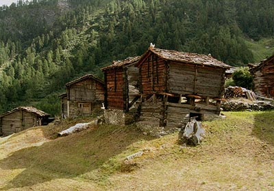
After nearly two hours of traversing, the path begins to descend back down to the valley floor and through to the village of Zmutt and its many old homes. This quaint village allows for a few moments of peace before the hustle of Zermatt. From Zmutt one needs about 1 hour to return to Zermatt.
The trail system in and around Zermatt is very well marked and should pose no problems when trying to complete this route.
Suggested Maps
 Landeskarte der Schweiz - 1:50000 - Sheet SW 5006 - Matterhorn/Mischabel
Recommended Books
Walking in the Alps
 An outstanding and comprehensive book exploring the walking and trekking possibilities in every Alpine region. Many thousands of possible routes are suggested, from the Maritime Alps of southern France throughout the range to the Julian Alps of Slovenia. Walks vary from undemanding to long and tough, and everything in between.
Tour of the Jungfrau Region
 A guidebook to the Tour of the Jungfrau Region, a 111km trek from Schynige Platte to Wilderswil in 9-12 days through the Bernese Oberland under the Mönch, Eiger and Jungfrau, exploring both well-known and hidden valleys, surrounded by soaring peaks, glaciers, lakes and ridges. A good first Alpine trek with plenty of bad-weather alternatives.
Stay Safe
Do enjoy yourself when out walking and choose a route that is within your capabilities especially with regard to navigation.
Do turn back if the weather deteriorates especially in winter or when visibility is poor.
Do wear the right clothing for the anticipated weather conditions. If the weather is likely to change for the worse make sure you have enough extra clothing in your pack.
Do tell someone where you are planning to walk especially in areas that see few other walkers.
Do take maps and other navigational aids. Do not rely on mobile devices in areas where reception is poor. Take spare batteries especially in cold weather.
Do check the weather forecast before leaving.
Do do not exceed your capabilities.
Please Note - These walks have been published for use by site visitors on the understanding that Walking Sitzerland is not held responsible for the safety or well being of those following the routes as described. It is worth reiterating the point that you should embark on a walk with the correct maps at the most detailed scale where possible. This will enable any difficulties with route finding to be assessed, and corrective action taken if necessary.