Murren (Allmendhubel) - MurrenWalk 8031
Canton - Bern / Berne - Jungfrau Region
Author - Lou Johnson
Length - 6.0 km / 3.8 miles
Ascent - 50 metres / 165 feet
Descent - 270 metres / 891 feet
Time - 2.00 hours
Grade - easy/moderate
Click image to visit gallery image.
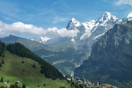
An enjoyable circuit above the village of Mürren. Using the funicular to Allmendhubel the route descends gently through the outskirts of Mürren with some excellent mountain views throughout the walk.
Start the top station of the Allmendhubel funicular from the centre of Mürren. See Transport Map for the Jungfrau Region.
End the village centre of Mürren.
From the upper street in Mürren locate the bottom station of the Allmendhubel funicular. From here walk south and locate a path junction about 200 metres from the funicular station. Turn right here and climb steeply on a tarmac path passing Pension Sonnenberg, which is the first of many restaurants on this route. Stay on the broad path and continue to Suppenalp (refreshments).
Follow the path signed 'Schiltalp'. The path climbs a little and goes under the Schilthorn cablecar to present you with some wonderful views with the Gspaltenhorn worthy of special attention to the Southwest. Shiltalp is small alpine farm with more refreshments. From here take the signed path to Spielbodenalp. However do not cross the river prior to this farm, instead bearing left and follow the clear path via Gimmela back to Mürren.
Suggested Maps
 Landeskarte der Schweiz - 1:50000 - Sheet SW 5004 - Berner Oberland
Landeskarte der Schweiz - 1:25000 - Sheet SW 2520 - Jungfrau Region
Wanderkarte - Wengen, Mürren & Lauterbrunnental - 1:40000
Recommended Books
Walking in the Valais
 Comprehensive guidebook to the Valais region, describing 111 day walks and 10 multi-day tours. Home to the Matterhorn and Dent Blanche, the routes are in the Fieschertal and the Aletsch glacier region, the Lötschental, Saastal, Mattertal, Turtmanntal, Val d'Anniviers, Val d'Herens, Val de Bagnes, Val Ferret and Vallée du Trient.
The Swiss Alpine Pass Route - Via Alpina Route 1
 Guidebook to the Alpine Pass Route following the Swiss Via Alpina 1, a 360km trek east-west across Switzerland, from Sargans, on the border of Liechtenstein, to Montreux, including prologue from Liechtenstein. A demanding 3-week trek described in 18 stages, crossing 16 passes including the 2778m Hohtürli. Requires good fitness and experience.
Stay Safe
Do enjoy yourself when out walking and choose a route that is within your capabilities especially with regard to navigation.
Do turn back if the weather deteriorates especially in winter or when visibility is poor.
Do wear the right clothing for the anticipated weather conditions. If the weather is likely to change for the worse make sure you have enough extra clothing in your pack.
Do tell someone where you are planning to walk especially in areas that see few other walkers.
Do take maps and other navigational aids. Do not rely on mobile devices in areas where reception is poor. Take spare batteries especially in cold weather.
Do check the weather forecast before leaving.
Do do not exceed your capabilities.
Please Note - These walks have been published for use by site visitors on the understanding that Walking Sitzerland is not held responsible for the safety or well being of those following the routes as described. It is worth reiterating the point that you should embark on a walk with the correct maps at the most detailed scale where possible. This will enable any difficulties with route finding to be assessed, and corrective action taken if necessary.