Kandersteg - EggeschwandWalk 8035
Canton - Bern / Berne - Kandertal
Author - Lou Johnson
Length - 3.5 km / 2.2 miles
Ascent - 20 metres / 66 feet
Descent - nominal or unknown
Time - 1.00 hours
Grade - easy
Click image to visit gallery image.
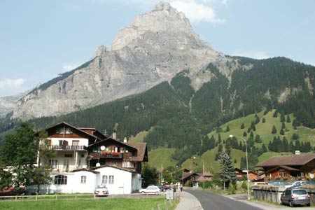
An undemanding valley walk that follows the River Kander upstream from Kandersteg. The route passes farms and offers some good views of the surrounding mountains.
Start Kandersteg Railway Station. Regular trains from Spiez (with connections from Interlaken) and Brig. Also bus service from Frutigen. See Transport Map for the Kandertal Region.
End the valley station of the Luftseilbahn Kandersteg-Sunnbüel. From here buses can take you back to Kandersteg.
From the Railway Station, turn south along the road in front of the station building following the signs for the cable car to Allmenalp cable car station. At the southern end of the station turn right and follow the road under the railway. Stay on this road until it goes alongside the River Kander about 200 metres before the cable car station. Turn left off the road onto the riverside path.
This follows the river to reach the main road. Just before the road turn right on the continuing path that crosses meadows. You will see the Kandersteg-Sunnbüel cable car station on your left. Continue some way past this to reach a footpath junction. Turn left here and walk the short distance down to the road. Turn left along the road and the cable car station is a short way along on your right.
Suggested Maps
 Landeskarte der Schweiz - 1:50000 - Sheet SW 5004 - Berner Oberland
Landeskarte der Schweiz - 1:50000 - Sheet SW5009 - Gstaad - Adelboden
Kandersteg Wanderkarte - 1:25000
Recommended Books
The Tour of the Bernina
 Guidebook describing a 9-stage (119km) route around the Piz Bernina massif in the Alps on the Swiss-Italian border near St Moritz, and the 8-stage (94km) Alta Via Valmalenco exploring the Valmalenco valley, in the shadow of Monte Disgrazia. The Tour of the Bernina is suitable for first-time trekkers but the Alta Via needs some experience.
Tour of the Matterhorn
 A guide to the 145km Tour of the Matterhorn, described anti-clockwise from Zermatt and visits 6 valleys via Zinal, Arolla and Breuil, offering spectacular views of 25 peaks of over 4000m. The route also links up with the Chamonix to Zermatt walkers' Haute Route and the Tour of Monte Rosa. Includes two glacier crossings and takes 8 to 10 days.
Stay Safe
Do enjoy yourself when out walking and choose a route that is within your capabilities especially with regard to navigation.
Do turn back if the weather deteriorates especially in winter or when visibility is poor.
Do wear the right clothing for the anticipated weather conditions. If the weather is likely to change for the worse make sure you have enough extra clothing in your pack.
Do tell someone where you are planning to walk especially in areas that see few other walkers.
Do take maps and other navigational aids. Do not rely on mobile devices in areas where reception is poor. Take spare batteries especially in cold weather.
Do check the weather forecast before leaving.
Do do not exceed your capabilities.
Please Note - These walks have been published for use by site visitors on the understanding that Walking Sitzerland is not held responsible for the safety or well being of those following the routes as described. It is worth reiterating the point that you should embark on a walk with the correct maps at the most detailed scale where possible. This will enable any difficulties with route finding to be assessed, and corrective action taken if necessary.