Piz Nair - Suvretta - Sils Maria Walk 8068
Canton - Graubunden/Grisons - Upper Engadine
Author - Lou Johnson
Length - 13.0 km / 8.1 miles
Ascent - 100 metres / 330 feet
Descent - 1400 metres / 4620 feet
Time - 4.00 hours
Grade - moderate
Click image to visit gallery of 3 images.
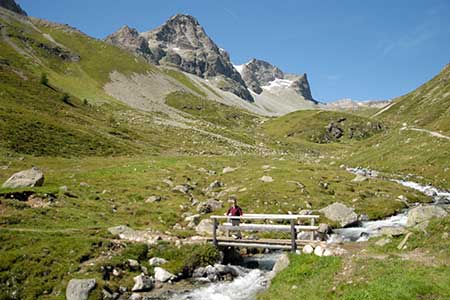
To reach the start from St Moritz take the 2-stage funicular to Corviglia and continue on the cable car to the summit of Piz Nair (3022m) from where there are excellent views. Refreshments are available here and are the only opportunity until you reach Sils Maria.
From the cable car station follow the path down to Pass Suvretta. This starts on the northern side of the station. As you approach Lej Suvretta ignore the path to Corviglia and continue to follow signs to Pass Suvretta. From the lake turn left following the signs to Champfér.
As you descend ignore side paths and continue past Chaschigna to reach Alp Suvretta where you bear right towards Champfér. Follow this path with the river on your right to reach a footbridge (2145 metres). Go right across the bridge. Continue along this path following signs to Silvaplana and Segl. Reaching Orchas (2198m) bear left along a track descending towards Silvaplana. After a few minutes turn right following the signed Via Engadin.
Nearing the road over the Güglia Pass you reach a junction. Follow the signs to Segl. You reach the road. Take care crossing this busy road and turn right, then fork left following the signs to Segl. Reaching a bridge turn left over the river. Ignore the footpath on your right to Segl Baselgia and continue ahead on the track (Via Engiadina). 100 metres after this junction fork left and descend. After a further 150 metres bear right signed Segl.
The route is never in doubt and you have some views to Silvaplana Lake on your right. The descent towards Fölias is easy. Cross the bridge here and follow the signed path through the buildings to reach the main road (1798m). Cross the road using the pedestrian crossing and walk into Sils/Segl Maria using the path on the east side of the road.
If you wish to return to St Moritz there is a regular bus service that departs from near the Post Office which is on your left as you walk into the village.
Suggested Maps
 Oberengadin, Bergell-Puschlav, Wanderkarte - 1:50000
Recommended Books
Walking in the Valais
 Comprehensive guidebook to the Valais region, describing 111 day walks and 10 multi-day tours. Home to the Matterhorn and Dent Blanche, the routes are in the Fieschertal and the Aletsch glacier region, the Lötschental, Saastal, Mattertal, Turtmanntal, Val d'Anniviers, Val d'Herens, Val de Bagnes, Val Ferret and Vallée du Trient.
The Swiss Alps
 A comprehensive guidebook to every mountain area in the Swiss Alps. This handy resource includes information for walking, hiking, trekking, climbing and ski mountaineering. Access, accommodation and facilities in the valley bases and full information about Swiss mountain huts is included to help you make the most out of a trip there.
Stay Safe
Do enjoy yourself when out walking and choose a route that is within your capabilities especially with regard to navigation.
Do turn back if the weather deteriorates especially in winter or when visibility is poor.
Do wear the right clothing for the anticipated weather conditions. If the weather is likely to change for the worse make sure you have enough extra clothing in your pack.
Do tell someone where you are planning to walk especially in areas that see few other walkers.
Do take maps and other navigational aids. Do not rely on mobile devices in areas where reception is poor. Take spare batteries especially in cold weather.
Do check the weather forecast before leaving.
Do do not exceed your capabilities.
Please Note - These walks have been published for use by site visitors on the understanding that Walking Sitzerland is not held responsible for the safety or well being of those following the routes as described. It is worth reiterating the point that you should embark on a walk with the correct maps at the most detailed scale where possible. This will enable any difficulties with route finding to be assessed, and corrective action taken if necessary.