Grutschalp - Winteregg - MurrenWalk 8002
Canton - Bern / Berne - Jungfrau Region
Author - Lou Johnson
Length - 4.5 km / 2.8 miles
Ascent - 150 metres / 495 feet
Descent - nominal or unknown
Time - 1.50 hours
Grade - easy
Click image to visit gallery of 3 images.
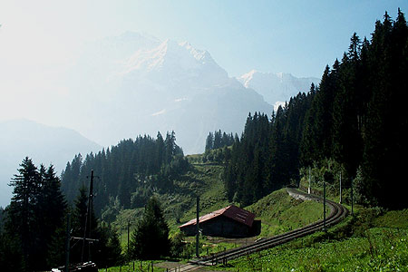
This easy walk makes an ideal short excursion. The path runs alongside the railway that links Grütschalp with the traffic free village of Mürren. Winteregg, the halfway point, has the benefit of a restaurant so you can make this a very leisurely half day excursion enjoying excellent views all the way.
Start - the upper station of the Lauterbrunnen to Grutschalp cablecar, which takes just 4 minutes to complete the 690 metre height difference. The service runs frequently and connects with trains to and from Murren. See Transport Map for the Jungfrau Region.
End - the railway station in Mürren where regular trains take you back to Grütschalp with connections to Lauterbrunnen.
Exit the cablecar station and turn left. Cross the railway tracks to reach a broad path. Turn left and keeping the railway on your left, continue south parallel to the narrow gauge railway tracks. Far below to your left is the Lauterbrunnen valley with the resort of Wengen and the Männlichen ridge beyond. The path climbs steadily but remains easy to reach Winteregg with its restaurant, dairy farm and ski-lift.
The highlight of the walk is the view to the Jungfrau (4158m), Mönch (4107 m) and Eiger (3970 m). This trio of superb mountains and their glaciers hold your attention for most of the walk. The gradual climb continues until you near Mürren station. This les on the northern end of the village with the cluster of shops, hotels and chalets occupying a ledge some 700 metres above the valley floor.
Suggested Maps
 Landeskarte der Schweiz - 1:50000 - Sheet SW 5004 - Berner Oberland
Landeskarte der Schweiz - 1:25000 - Sheet SW 2520 - Jungfrau Region
Wanderkarte - Wengen, Mürren & Lauterbrunnental - 1:40000
Recommended Books
Alpine Flowers
 A pocket field guidebook for identifying 230 of the most commonly found alpine flowers of the Alps. Categorised by colour for quick identification, each alpine flower has a photograph and description of its key features. Flower names are given in English, French, German, Italian and Latin, with notes on curious facts and origins of names.
Walking in the Alps
 An outstanding and comprehensive book exploring the walking and trekking possibilities in every Alpine region. Many thousands of possible routes are suggested, from the Maritime Alps of southern France throughout the range to the Julian Alps of Slovenia. Walks vary from undemanding to long and tough, and everything in between.
Stay Safe
Do enjoy yourself when out walking and choose a route that is within your capabilities especially with regard to navigation.
Do turn back if the weather deteriorates especially in winter or when visibility is poor.
Do wear the right clothing for the anticipated weather conditions. If the weather is likely to change for the worse make sure you have enough extra clothing in your pack.
Do tell someone where you are planning to walk especially in areas that see few other walkers.
Do take maps and other navigational aids. Do not rely on mobile devices in areas where reception is poor. Take spare batteries especially in cold weather.
Do check the weather forecast before leaving.
Do do not exceed your capabilities.
Please Note - These walks have been published for use by site visitors on the understanding that Walking Sitzerland is not held responsible for the safety or well being of those following the routes as described. It is worth reiterating the point that you should embark on a walk with the correct maps at the most detailed scale where possible. This will enable any difficulties with route finding to be assessed, and corrective action taken if necessary.