Kandersteg (Allmenalp) - Kandersteg (Eggeschwand)Walk 8014
Canton - Bern / Berne - Kandertal
Author - Lou Johnson
Length - 7.0 km / 4.4 miles
Ascent - 50 metres / 165 feet
Descent - 600 metres / 1980 feet
Time - 2.00 hours
Grade - easy/moderate
Click image to visit gallery of 10 images.
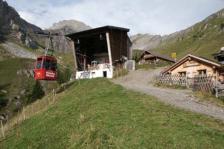
The walk starts at the upper station of the Allmenalp cablecar. Small 8 person cabins whisk you above Kandertal onto the alp. There are refreshments adjacent to the upper cablecar station. You will also note signs to the paragliding launch slopes at Allmenalp and Ryharts. Across the valley you can see the Oeshinensee with the Blümlisalp massif rising above.
Start - The upper station of the Allmenalp cablecar. The valley station is ten minutes walk from Kandersteg railway station. Regular trains from Spiez (with connections from Interlaken) and Brig. Also bus service from Frutigen. See Transport Map for the Kandertal Region.
End - The valley station of the Sunnbüel Gemmi Pass cablecar. From here buses operate to Kandersteg station or you can follow the footpath back to Kandersteg (30 min.).
Leave the cablecar station and head uphill with the Bunderspitz filling the view ahead. After a short way you arrive at a path junction where you go left to Usser Uschene (1hr. 10 min.). The path drops to a metal footbridge across a stream before climbing to pass a farm on your left. This also sells refreshments, cheese and milk. The path then contours the hillside before becoming a wider track. Ahead you have excellent and improving views of with the Uschenengrat ridge rising on the left hand wall of the valley.
Stay on this track through to the road junction in Usser Uschene ignoring all footpaths going left. At the road junction there is further opportunity for refreshments with the meringues recommended.
Turn left down the road towards Kandersteg and take the first footpath on the right. This path leads into the valley and follows a fast flowing torrent through forest with the lower crags of the Gallihorn soaring above to your right. The path provides convenient short cuts to the road, which takes a more circuitous route, and you descend quickly to reach a road junction where the road to Selden turns right. Continue ahead following the road to the cablecar station where refreshments are available.
Suggested Maps
 Landeskarte der Schweiz - 1:50000 - Sheet SW 5004 - Berner Oberland
Landeskarte der Schweiz - 1:50000 - Sheet SW5009 - Gstaad - Adelboden
Kandersteg Wanderkarte - 1:25000
Recommended Books
Walks in the Engadine - Switzerland
 A walking guidebook to 100 day walks in the Engadine, Val Bregaglia, neighbouring valleys and the Engadine National Park. Varying from gentle rambles to adventurous high-level routes for the experienced mountain walker. Each route ranges from 2 to 10 miles long, visiting forests and meadows, high mountain landscapes, lakes and passes.
Walking in the Alps
 An outstanding and comprehensive book exploring the walking and trekking possibilities in every Alpine region. Many thousands of possible routes are suggested, from the Maritime Alps of southern France throughout the range to the Julian Alps of Slovenia. Walks vary from undemanding to long and tough, and everything in between.
Stay Safe
Do enjoy yourself when out walking and choose a route that is within your capabilities especially with regard to navigation.
Do turn back if the weather deteriorates especially in winter or when visibility is poor.
Do wear the right clothing for the anticipated weather conditions. If the weather is likely to change for the worse make sure you have enough extra clothing in your pack.
Do tell someone where you are planning to walk especially in areas that see few other walkers.
Do take maps and other navigational aids. Do not rely on mobile devices in areas where reception is poor. Take spare batteries especially in cold weather.
Do check the weather forecast before leaving.
Do do not exceed your capabilities.
Please Note - These walks have been published for use by site visitors on the understanding that Walking Sitzerland is not held responsible for the safety or well being of those following the routes as described. It is worth reiterating the point that you should embark on a walk with the correct maps at the most detailed scale where possible. This will enable any difficulties with route finding to be assessed, and corrective action taken if necessary.