Gemmipass - SchwarenbachWalk 8042
Canton - Valais / Wallis - Leukerbad & Gemmipass
Author - Lou Johnson
Length - 4.5 km / 2.8 miles
Ascent - nominal or unknown
Descent - 280 metres / 924 feet
Time - 1.50 hours
Grade - easy
Click image to visit gallery of 2 images.
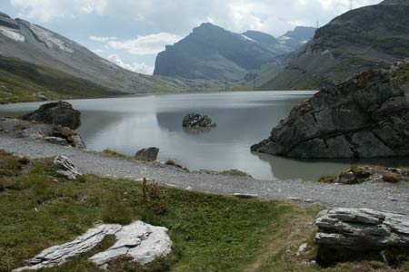
A straightforward and mainly downhill route from the dramatic Gemmi Pass to the Berghotel Schwarenbach. The route follows the shore of the Daubensee and also benefits from some fine mountain scenery.
Start the upper station of the Gemmibahn from Leukerbad to the Gemmi Pass. See Transport Map for the Kandertal Region.
End the Berghotel Schwarenbach
Exit the upper station of the Gemmibahn and make your way to the pass. The view over the Rhone Valley and the Alps beyond is a one of the great panoramas in Europe with dozens of well known peaks included in the picture. From here descend to the shores of the Daubensee following the path to the Berghotel Schwarenbach.
Keeping the lake on your left, continue to the northern end where you stay on the main path at the junction. The Berghotel Schwarenbach is a short way further offering a wide range of refreshments in season.
To continue this route follow Walk 8043.
Suggested Maps
 Landeskarte der Schweiz - 1:50000 - Sheet SW 5004 - Berner Oberland
Landeskarte der Schweiz - 1:50000 - Sheet SW5009 - Gstaad - Adelboden
Kandersteg Wanderkarte - 1:25000
Recommended Books
The Tour of the Bernina
 Guidebook describing a 9-stage (119km) route around the Piz Bernina massif in the Alps on the Swiss-Italian border near St Moritz, and the 8-stage (94km) Alta Via Valmalenco exploring the Valmalenco valley, in the shadow of Monte Disgrazia. The Tour of the Bernina is suitable for first-time trekkers but the Alta Via needs some experience.
Walking in the Bernese Oberland
 This walking guidebook to the Bernese Oberland describes 113 day walks. Routes range from 2 to 24km and offer breathtaking scenery of the classic Eiger, Mönch and Jungfrau mountains, around Grindelwald, Lauterbrunnen, Gsteig and Meiringen. There are routes suitable for all abilities from short flat walks to adventurous treks.
Stay Safe
Do enjoy yourself when out walking and choose a route that is within your capabilities especially with regard to navigation.
Do turn back if the weather deteriorates especially in winter or when visibility is poor.
Do wear the right clothing for the anticipated weather conditions. If the weather is likely to change for the worse make sure you have enough extra clothing in your pack.
Do tell someone where you are planning to walk especially in areas that see few other walkers.
Do take maps and other navigational aids. Do not rely on mobile devices in areas where reception is poor. Take spare batteries especially in cold weather.
Do check the weather forecast before leaving.
Do do not exceed your capabilities.
Please Note - These walks have been published for use by site visitors on the understanding that Walking Sitzerland is not held responsible for the safety or well being of those following the routes as described. It is worth reiterating the point that you should embark on a walk with the correct maps at the most detailed scale where possible. This will enable any difficulties with route finding to be assessed, and corrective action taken if necessary.