Grutschalp - Allmendhubel - MurrenWalk 8001
Canton - Bern / Berne - Jungfrau Region
Author - Lou Johnson
Length - 6.0 km / 3.8 miles
Ascent - 450 metres / 1485 feet
Descent - 410 metres / 1353 feet
Time - 2.50 hours
Grade - easy/moderate
Click image to visit gallery of 6 images.
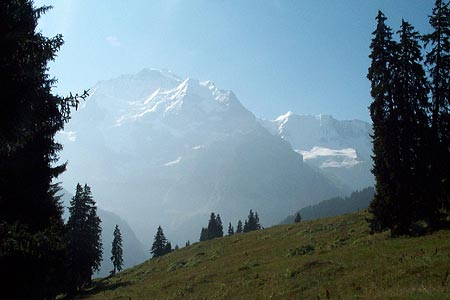
This walk provides a useful introduction to the area with excellent views of the three main peaks - the Jungfrau, Eiger and Mönch - together with an excellent overview of the landscape of the Lauterbrunnen to Mürren area.
Start - the upper station of the Lauterbrunnen to Grütschalp cablecar, which takes just 4 minutes to complete the 690 metre height difference. The service runs frequently and connects with trains to and from Mürren. See Transport Map for the Jungfrau Region.
End - the railway station in Mürren where regular trains take you back to Grütschalp with connections to Lauterbrunnen.
Exit the funicular station and turn left. Cross the railway tracks and follow the footpath to a junction. Turn left following the signs for Allmendhubel (2h 30m). The path forks right off the wider direct path that leads alongside the railway to Mürren and begins to climb steadily through a mixture of woodland and pasture. The views improve immediately with the Jungfrau (4158m), Mönch (4107 m) and Eiger (3970 m) looking majestic across the Lauterbrunnen valley. As with all paths in this area the signs and waymarks are excellent with arrival at Pletschanalp unlikely to have tested your navigation skills.
Ignore the path forking left that descends to Winteregg and keep to the high level path that contours easily across the mountainside. A short descent and reascent bring you to a rocky area just west of Maulerhubel. From here a descent into a wide grassy area and a steeper climb out bring you to the col west of Allmendhubel. Turn right and follow the sign to the top station of the Allmendhubel funicular to enjoy the view before returning to the col from where an easy descent into the traffic free village of Mürren is signed.
Suggested Maps
 Landeskarte der Schweiz - 1:50000 - Sheet SW 5004 - Berner Oberland
Landeskarte der Schweiz - 1:25000 - Sheet SW 2520 - Jungfrau Region
Wanderkarte - Wengen, Mürren & Lauterbrunnental - 1:40000
Recommended Books
Walking in the Bernese Oberland
 This walking guidebook to the Bernese Oberland describes 113 day walks. Routes range from 2 to 24km and offer breathtaking scenery of the classic Eiger, Mönch and Jungfrau mountains, around Grindelwald, Lauterbrunnen, Gsteig and Meiringen. There are routes suitable for all abilities from short flat walks to adventurous treks.
Tour of Monte Rosa
 A guidebook to walking the The Tour of Monte Rosa, a 9-10 day, 134km trek circling Monte Rosa anti-clockwise from Zermatt. The high route hugs glaciers and has views of over ten 4000ers. All essential information is provided, including outline maps, route profiles, advice on glacier crossing and accommodation.
Stay Safe
Do enjoy yourself when out walking and choose a route that is within your capabilities especially with regard to navigation.
Do turn back if the weather deteriorates especially in winter or when visibility is poor.
Do wear the right clothing for the anticipated weather conditions. If the weather is likely to change for the worse make sure you have enough extra clothing in your pack.
Do tell someone where you are planning to walk especially in areas that see few other walkers.
Do take maps and other navigational aids. Do not rely on mobile devices in areas where reception is poor. Take spare batteries especially in cold weather.
Do check the weather forecast before leaving.
Do do not exceed your capabilities.
Please Note - These walks have been published for use by site visitors on the understanding that Walking Sitzerland is not held responsible for the safety or well being of those following the routes as described. It is worth reiterating the point that you should embark on a walk with the correct maps at the most detailed scale where possible. This will enable any difficulties with route finding to be assessed, and corrective action taken if necessary.