Murren - Gimmelwald - StechelbergWalk 8003
Canton - Bern / Berne - Jungfrau Region
Author - Lou Johnson
Length - 8.0 km / 5 miles
Ascent - 470 metres / 1551 feet
Descent - 1190 metres / 3927 feet
Time - 4.00 hours
Grade - moderate
Click image to visit gallery of 9 images.
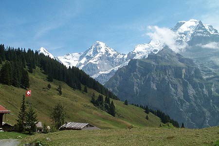
This walk explores the area to the south and southwest of Mürren. It uses well maintained and signed paths throughout. The views are excellent not only to the Eiger, Mönch, and Jungfrau but also the string of peaks that head west from the latter summit with the Breithorn of particular note. The earlier stages of the route follow the "Northface Trail" with information boards placed at regular intervals describing the routes of ascent for the major peaks in view. It is also worth noting that the ascent can be reduced by taking the Allmendhubel funicular to pick up the route near Sonnenberg. For those who wish to reduce the amount of descent then you can use the cablecar from Gimmelwald to the valley floor.
Start - the walk begins in the village of Mürren, which can be reached by funicular and train from Lauterbrunnen or cablecar from Stechelberg. See Transport Map for the Jungfrau Region.
End - the route ends in Stechelberg village centre, which is about 1 km from the cablecar station. Stechelberg is linked to Lauterbrunnen by postbuses, which connect with trains to Interlaken, Wengen and Grindelwald.
From the upper street in Mürren locate the bottom station of the Allmendhubel funicular. From here walk south and locate a path junction about 200 metres from the funicular station. Turn right here and climb steeply on a tarmac path passing Pension Sonnenberg, which is the first of many restaurants on this route. Stay on the broad path and continue to Suppenalp (refreshments). Leave the main path here and turn right. Follow the path signed 'Schiltalp'. The path climbs a little and goes under the Schilthorn cablecar to present you with some wonderful views with the Gspaltenhorn worthy of special attention to the Southwest
Shiltalp is small alpine farm with more refreshments. From here take the signed path to Spielbodenalp. This path goes left downhill to cross the river on a wooden footbridge. Pass through the small farm (refreshments) to reach a path junction just past the farm buildings. Take the left hand path. This leads to another path junction after a few minutes. Cross the footbridge and turn right to descend through woodland to Gimmelwald. The path leaves the trees to join a road. Cross over and continue the descent through the scattered buildings of the village to reach the cablecar station.
Other refreshment opportunities are available Gimmelwald. To continue turn south following the path signed to Stechelberg. The descent into Sefinental is continuous to reach a river bridge in the valley. Cross this and, keeping left, continue the descent through forest with the river on your left to pass one impressive waterfall and a number of smaller cascades. Note the signs warning you of possible rock-falls. There is one path junction that lacks a sign but you will discover that both paths soon join together again for the final section to Stechelberg. The Postbus terminus is a few hundred metres north along the main road.
Suggested Maps
 Landeskarte der Schweiz - 1:50000 - Sheet SW 5004 - Berner Oberland
Landeskarte der Schweiz - 1:25000 - Sheet SW 2520 - Jungfrau Region
Wanderkarte - Wengen, Mürren & Lauterbrunnental - 1:40000
Recommended Books
Walking in the Bernese Oberland
 This walking guidebook to the Bernese Oberland describes 113 day walks. Routes range from 2 to 24km and offer breathtaking scenery of the classic Eiger, Mönch and Jungfrau mountains, around Grindelwald, Lauterbrunnen, Gsteig and Meiringen. There are routes suitable for all abilities from short flat walks to adventurous treks.
Trekking in the Silvretta and Rätikon Alps
 This guide describes three treks, between 5 and 8 days, in the Silvretta and Rätikon Alps starting near Klosters, and 12 half-day hut-to-hut routes. These contrasting ranges form a line on the borders of Switzerland, Austria and Liechtenstein. The Tour of the Silvretta, the Prättigauer Höhenweg and the Rätikon Höhenweg.
Stay Safe
Do enjoy yourself when out walking and choose a route that is within your capabilities especially with regard to navigation.
Do turn back if the weather deteriorates especially in winter or when visibility is poor.
Do wear the right clothing for the anticipated weather conditions. If the weather is likely to change for the worse make sure you have enough extra clothing in your pack.
Do tell someone where you are planning to walk especially in areas that see few other walkers.
Do take maps and other navigational aids. Do not rely on mobile devices in areas where reception is poor. Take spare batteries especially in cold weather.
Do check the weather forecast before leaving.
Do do not exceed your capabilities.
Please Note - These walks have been published for use by site visitors on the understanding that Walking Sitzerland is not held responsible for the safety or well being of those following the routes as described. It is worth reiterating the point that you should embark on a walk with the correct maps at the most detailed scale where possible. This will enable any difficulties with route finding to be assessed, and corrective action taken if necessary.