Schynige Platte - Panorama WalkWalk 8005
Canton - Bern / Berne - Jungfrau Region
Author - Lou Johnson
Length - 5.0 km / 3.1 miles
Ascent - 170 metres / 561 feet
Descent - nominal or unknown
Time - 2.50 hours
Grade - easy/moderate
Click image to visit gallery of 9 images.
This is a short walk on well trodden paths that offers wonderful views in all directions. The immediate surroundings are dramatic with rocky outcrops adding to the landscape. There are a few sections where those suffering from vertigo might have difficulties although there are fences giving some psychological encouragement. Despite the relatively short distance it is recommended that strong footwear is worn as the paths used are quite rough in places and could be slippery after rain.
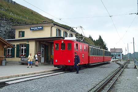
Start & End - the railway station at Schynige Platte which has a regular train service from Wilderswil, where connections to Lauterbrunnen, Grindelwald and Interlaken are available. See Transport Map for the Jungfrau Region.
From the railway station walk southwest alongside the tracks towards the hotel. Clear signs directs you onto the Panorama path. At first the views over Interlaken and Lake Thun keep you occupied but as the path climbs and swings north you get your first views over Lake Brienz and the mountains rising from the Lake. The path then trends northeast with a dramatic drop on your left. You have the opportunity of visiting the summit of the Oberberghorn aided by some substantial ladders and this minor summit offers a 360 degree panorama with grand views south including the Jungfrau, Eiger and Mönch and many other peaks.
The path keeping to the edge offers the most exciting route although there are other paths running parallel. and these may be preferred by those without a head for heights. From the Oberberghorn the path descends gently with a ladder making an otherwise difficult descent very easy. Ahead lies the Loucherhorn and reaching the base of this at Louchera, you join the main direct path from Schynige Platte to the Faulhorn. Turn right and walk back through alpine meadows passing the alpine farm of Oberberg to the railway station.
Refreshments are available at Schynige Platte where there is an interesting Alpine Garden.
Suggested Maps
 Landeskarte der Schweiz - 1:50000 - Sheet SW 5004 - Berner Oberland
Landeskarte der Schweiz - 1:25000 - Sheet SW 2520 - Jungfrau Region
Wanderkarte - Wengen, Mürren & Lauterbrunnental - 1:40000
Recommended Books
Trekking in the Silvretta and Rätikon Alps
 This guide describes three treks, between 5 and 8 days, in the Silvretta and Rätikon Alps starting near Klosters, and 12 half-day hut-to-hut routes. These contrasting ranges form a line on the borders of Switzerland, Austria and Liechtenstein. The Tour of the Silvretta, the Prättigauer Höhenweg and the Rätikon Höhenweg.
The Tour of the Bernina
 Guidebook describing a 9-stage (119km) route around the Piz Bernina massif in the Alps on the Swiss-Italian border near St Moritz, and the 8-stage (94km) Alta Via Valmalenco exploring the Valmalenco valley, in the shadow of Monte Disgrazia. The Tour of the Bernina is suitable for first-time trekkers but the Alta Via needs some experience.
Stay Safe
Do enjoy yourself when out walking and choose a route that is within your capabilities especially with regard to navigation.
Do turn back if the weather deteriorates especially in winter or when visibility is poor.
Do wear the right clothing for the anticipated weather conditions. If the weather is likely to change for the worse make sure you have enough extra clothing in your pack.
Do tell someone where you are planning to walk especially in areas that see few other walkers.
Do take maps and other navigational aids. Do not rely on mobile devices in areas where reception is poor. Take spare batteries especially in cold weather.
Do check the weather forecast before leaving.
Do do not exceed your capabilities.
Please Note - These walks have been published for use by site visitors on the understanding that Walking Sitzerland is not held responsible for the safety or well being of those following the routes as described. It is worth reiterating the point that you should embark on a walk with the correct maps at the most detailed scale where possible. This will enable any difficulties with route finding to be assessed, and corrective action taken if necessary.