Schynige Platte - Faulhorn - Bachalpsee - FirstWalk 8006
Canton - Bern / Berne - Jungfrau Region
Author - Lou Johnson
Length - 16.0 km / 10 miles
Ascent - 980 metres / 3234 feet
Descent - 770 metres / 2541 feet
Time - 5.50 hours
Grade - moderate/hard
Click image to visit gallery of 12 images.
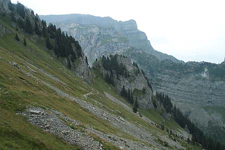
One of the classic walks in the Bernese Oberland. The views and immediate scenery are superb even on a cloudy day. With sun and good visibility this walk would be hard to better. The paths are generally good although there are some sections that occasional walkers may find hard going. Good footwear is essential and you need to be prepared for bad weather en-route as there are some lengthy sections without shelter.
Start - the railway station at Schynige Platte which has a regular train service from Wilderswil, where connections from Lauterbrunnen, Grindelwald and Interlaken are available. See Transport Map for the Jungfrau Region.
End - top station of the Grindelwald to First gondola lift. This provides a comfortable and scenic descent with connections in Grindelwald by train and post bus to destinations throughout the area.
From Schynige Platte railway station head southwest alongside the railway track past the hotel and continue on the Panorama walk as described in walk 005. This leads you along a superb ridge with fine views on both sides. If you are short of time you can take the direct path from the station signed "Faulhorn" via Oberberg but this does mean you miss an excellent section of route.
Both routes join just west of Loucherhorn at Louchera from where the path climbs and contours across the southern slopes of this mountain. Turning north the path then enters a large rocky amphitheatre with some amazing folds of rock in evidence. Continuing past two paths coming in from south and north at Egg, the route makes a lengthy traverse across the northern edge of the Indri Sägissa with good views right into Sägistal with its small lake.
The next section is superb with the path turning south to ascend through rocks to the Weber Hut or Berghaus-Männdlenen where refreshments can normally be obtained. The hut is located in the col named Männdlenen from where an escape path descends south to Burglauenen should the weather turn bad. Turning east again, our route climbs steadily onto a stony plateau, which forms the eastern extension of the Winteregg ridge, with the Faulhorn coming into sight ahead. There is steep path directly to the summit but the easier way is to continue a little way past and take the wide track to the summit hotel (refreshments and accommodation). The view from the summit is superb encompassing a full 360 degrees with mountains galore.
Descend from the Faulhorn using the same track used on the ascent bearing left to follow the onward route to the path junction at Gassenboden where you take the route signed to First. The path continues to descend into the beautiful valley containing Bachalpsee with the Reeti rising on your right. Reaching the lake stay on the northern shores following the clear signs for First taking care to enjoy the wonderful view across the lake to the Wetterhorn and Schreckhorn.
The final stretch of the route involves a short climb before a gentle descent to the top station of the Grindelwald to First gondola lift. On this final section the shrill whistles of Marmots were heard and two separate colonies were spotted basking on rocks. Take note that there is one path junction close to First that is not signed where the right hand track offers the most direct route to the end of the walk.
Suggested Maps
 Landeskarte der Schweiz - 1:50000 - Sheet SW 5004 - Berner Oberland
Landeskarte der Schweiz - 1:25000 - Sheet SW 2520 - Jungfrau Region
Wanderkarte - Wengen, Mürren & Lauterbrunnental - 1:40000
Recommended Books
Walking in the Bernese Oberland
 This walking guidebook to the Bernese Oberland describes 113 day walks. Routes range from 2 to 24km and offer breathtaking scenery of the classic Eiger, Mönch and Jungfrau mountains, around Grindelwald, Lauterbrunnen, Gsteig and Meiringen. There are routes suitable for all abilities from short flat walks to adventurous treks.
100 Hut Walks in the Alps
 This guidebook has route descriptions for 100 day walks to suit alpine walkers of all abilities, with suggestions for some hut-to-hut tours. These routes take you through breathtaking scenery in the Maritime Alps, Julian Alps, Gran Paradiso, the Turnitzer Alps, Bernese Oberland, the Kitzbuheler Alps and the Dolomites of South Tirol.
Stay Safe
Do enjoy yourself when out walking and choose a route that is within your capabilities especially with regard to navigation.
Do turn back if the weather deteriorates especially in winter or when visibility is poor.
Do wear the right clothing for the anticipated weather conditions. If the weather is likely to change for the worse make sure you have enough extra clothing in your pack.
Do tell someone where you are planning to walk especially in areas that see few other walkers.
Do take maps and other navigational aids. Do not rely on mobile devices in areas where reception is poor. Take spare batteries especially in cold weather.
Do check the weather forecast before leaving.
Do do not exceed your capabilities.
Please Note - These walks have been published for use by site visitors on the understanding that Walking Sitzerland is not held responsible for the safety or well being of those following the routes as described. It is worth reiterating the point that you should embark on a walk with the correct maps at the most detailed scale where possible. This will enable any difficulties with route finding to be assessed, and corrective action taken if necessary.