Pfingstegg - GrindelwaldWalk 8010
Canton - Bern / Berne - Jungfrau Region
Author - Lou Johnson
Length - 7.0 km / 4.4 miles
Ascent - 80 metres / 264 feet
Descent - 330 metres / 1089 feet
Time - 2.50 hours
Grade - easy/moderate
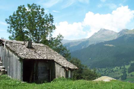
Click image to visit gallery of 11 images.
This walk is mainly downhill and there are no difficult sections. The views are good and the inclusion of the Upper Grindelwald Glacier adds interest. In addition you pass the site of first cablecar in the world that rose to the shoulder of the Wetterhorn.
Start - top station of the Grindelwald to Pfingstegg cable car. This provides an easy ascent. The lower station is about one kilometre from the train and post bus stations in the centre of Grindelwald. See Transport Map for the Jungfrau Region.
End - the railway station in Grindelwald where connections are available Lauterbrunnen, Interlaken etc. As an alternative you can terminate at the Hotel Wetterhorn and return by Post Bus to the centre of Grindelwald.
This route has been closed on occasions in recent years due to the potential danger from rockfalls. You are advised to enquire locally about possible closures prior to starting this walk.
From the top station of the Pfingstegg cablecar take the signed path to Milchbach. This is easy walking with varied terrain and views. After contouring across the flanks of the Mattenberg you reach the small restaurant Milchbach. Here you are able to see the Upper Grindelwald Glacier with the mighty Wetterhorn across the valley the glacier has carved from the rock. From Michbach there is a path that leads upwards for better views of the glacier although there is a charge and you must be competent to use the ladders provided on the more difficult sections.
The continuation takes you down through woods to the Hotel Wetterhorn. During the descent you will see on your right a small restaurant perched on a large rocky outcrop. This is reach by a stepped path and is subject to a admission charge. It does however provide a grand view of the glacier without the perils of the laddered ascent from Milchbach but still requires considerable ascent up steps.
Reaching the Wetterhorn hotel you can either return to Grindelwald by using the Post Bus service or walk to the end of the car park and follow the signed path to Grindelwald. This leads you gently downhill through woods, across a small gorge to reach alpine pastures for the final stretch into the village.
Suggested Maps
 Landeskarte der Schweiz - 1:50000 - Sheet SW 5004 - Berner Oberland
Landeskarte der Schweiz - 1:25000 - Sheet SW 2520 - Jungfrau Region
Wanderkarte - Wengen, Mürren & Lauterbrunnental - 1:40000
Recommended Books
Trekking in the Alps
 A book to 20 classic trekking routes in the Alps. Exploring the best trekking areas, outline descriptions and photographs illustrate the classics such as the Tour of Mont Blanc, and Chamonix to Zermatt, as well a number of trekking routes in Slovenia, the Italian Dolomites, the French Alps, Austrian Alps and Swiss Alps. Ideal for inspiration.
Tour of Mont Blanc
 An essential guidebook for walking the Tour of Mont Blanc. The 170km route typically takes 11 days to trek around the Mont Blanc massif. The TMB is recognised as one of the world's classic treks. The book describes both anti-clockwise and clockwise directions, with variants and information about huts, refuges and facilities en route.
Stay Safe
Do enjoy yourself when out walking and choose a route that is within your capabilities especially with regard to navigation.
Do turn back if the weather deteriorates especially in winter or when visibility is poor.
Do wear the right clothing for the anticipated weather conditions. If the weather is likely to change for the worse make sure you have enough extra clothing in your pack.
Do tell someone where you are planning to walk especially in areas that see few other walkers.
Do take maps and other navigational aids. Do not rely on mobile devices in areas where reception is poor. Take spare batteries especially in cold weather.
Do check the weather forecast before leaving.
Do do not exceed your capabilities.
Please Note - These walks have been published for use by site visitors on the understanding that Walking Sitzerland is not held responsible for the safety or well being of those following the routes as described. It is worth reiterating the point that you should embark on a walk with the correct maps at the most detailed scale where possible. This will enable any difficulties with route finding to be assessed, and corrective action taken if necessary.