Mannlichen - Kleine ScheideggWalk 8026
Canton - Bern / Berne - Jungfrau Region
Author - Lou Johnson
Length - 4.5 km / 2.8 miles
Ascent - 50 metres / 165 feet
Descent - 200 metres / 660 feet
Time - 1.25 hours
Grade - easy
Click image to visit gallery of 5 images.
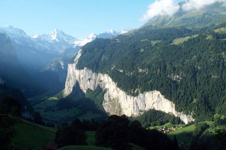
This easy, and very busy, walk offers superb views to the Eiger, Mönch and Jungfrau plus other peaks in the Grindelwald area including the Wetterhorn and Schreckhorn.
Start the top station of either the gondola cableway from Grindelwald or the cable car from Wengen. See Transport Map for the Jungfrau Region.
End Kleine Scheidegg station from where trains to Grindelwald and Wengen operate.
From the top station of either cableway at Männlichen make the short walk north to the summit of the Männlichen. Despite its modest appearance the Männlichen offers a grand panorama with the view to Schynige Platte and the Faulhorn amongst my favourite views in this area.
Having enjoyed the view, no doubt shared with countless others, head back towards the cableway stations and continue walking south along the broad path. This stays on the Grindelwald side of the ridge, by-passing the intermediate minor peaks of Tschuggen and the Lauberhorn to reach the busy station and hotel complex that constitutes Kleine Scheidegg.
Suggested Maps
 Landeskarte der Schweiz - 1:50000 - Sheet SW 5004 - Berner Oberland
Landeskarte der Schweiz - 1:25000 - Sheet SW 2520 - Jungfrau Region
Wanderkarte - Wengen, Mürren & Lauterbrunnental - 1:40000
Recommended Books
The Swiss Alpine Pass Route - Via Alpina Route 1
 Guidebook to the Alpine Pass Route following the Swiss Via Alpina 1, a 360km trek east-west across Switzerland, from Sargans, on the border of Liechtenstein, to Montreux, including prologue from Liechtenstein. A demanding 3-week trek described in 18 stages, crossing 16 passes including the 2778m Hohtürli. Requires good fitness and experience.
Tour of Monte Rosa
 A guidebook to walking the The Tour of Monte Rosa, a 9-10 day, 134km trek circling Monte Rosa anti-clockwise from Zermatt. The high route hugs glaciers and has views of over ten 4000ers. All essential information is provided, including outline maps, route profiles, advice on glacier crossing and accommodation.
Stay Safe
Do enjoy yourself when out walking and choose a route that is within your capabilities especially with regard to navigation.
Do turn back if the weather deteriorates especially in winter or when visibility is poor.
Do wear the right clothing for the anticipated weather conditions. If the weather is likely to change for the worse make sure you have enough extra clothing in your pack.
Do tell someone where you are planning to walk especially in areas that see few other walkers.
Do take maps and other navigational aids. Do not rely on mobile devices in areas where reception is poor. Take spare batteries especially in cold weather.
Do check the weather forecast before leaving.
Do do not exceed your capabilities.
Please Note - These walks have been published for use by site visitors on the understanding that Walking Sitzerland is not held responsible for the safety or well being of those following the routes as described. It is worth reiterating the point that you should embark on a walk with the correct maps at the most detailed scale where possible. This will enable any difficulties with route finding to be assessed, and corrective action taken if necessary.