Alpiglen - MannlichenWalk 8027
Canton - Bern / Berne - Jungfrau Region
Author - Lou Johnson
Length - 6.0 km / 3.8 miles
Ascent - 613 metres / 2023 feet
Descent - nominal or unknown
Time - 2.00 hours
Grade - easy/moderate
Click image to visit gallery image.
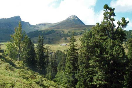
The path connecting Alpiglen to Männlichen offers some wonderful views to the Eiger, Mönch and Jungfrau. In addition Grindelwald and its backdrop of lesser peaks is also seen in some detail.
Start Alpiglen station, which is served by trains from Grindelwald and Wengen (via Kleine Scheidegg). See Transport Map for the Jungfrau Region.
End the top station of the gondola cableway from Grindelwald or the cable car from Wengen.
Exit Alpiglen station and follow the broad path uphill in a south-westerly direction towards Kleine Scheidegg following the railway, which should be on your right hand side. The way ahead climbs steadily with views across to the north face of the Eiger on your left. The path soon crosses the railway and continue past small alpine buildings at Mettla.
Shortly after you reach a path junction. Bear right here towards Bustiglen and Männlichen ignoring the path to Kleine Scheidegg going left. After passing Bustiglen bear left at the next junction to continue a steady climb across the eastern slopes of the Männlichen ridge. It is on this section that the view across Grindelwald to the Faulhorn and the Reeti is at its best. Having enjoyed a fairly quiet path from Bustiglen to the ridge you join the main ridge path for the final short section to Männlichen. Suddenly you are confronted by crowds of people enjoying the ridge path down to Kleine Scheidegg.
Continue past the cable car stations to the true summit of the Männlichen (2343m) from where there are more excellent views. After having enjoyed the extensive panorama return down the main path to the end of the walk at the cable car stations for either a descent to Wengen or Grindelwald.
Suggested Maps
 Landeskarte der Schweiz - 1:50000 - Sheet SW 5004 - Berner Oberland
Landeskarte der Schweiz - 1:25000 - Sheet SW 2520 - Jungfrau Region
Wanderkarte - Wengen, Mürren & Lauterbrunnental - 1:40000
Recommended Books
Alpine Flowers
 A pocket field guidebook for identifying 230 of the most commonly found alpine flowers of the Alps. Categorised by colour for quick identification, each alpine flower has a photograph and description of its key features. Flower names are given in English, French, German, Italian and Latin, with notes on curious facts and origins of names.
Trekking in the Silvretta and Rätikon Alps
 This guide describes three treks, between 5 and 8 days, in the Silvretta and Rätikon Alps starting near Klosters, and 12 half-day hut-to-hut routes. These contrasting ranges form a line on the borders of Switzerland, Austria and Liechtenstein. The Tour of the Silvretta, the Prättigauer Höhenweg and the Rätikon Höhenweg.
Stay Safe
Do enjoy yourself when out walking and choose a route that is within your capabilities especially with regard to navigation.
Do turn back if the weather deteriorates especially in winter or when visibility is poor.
Do wear the right clothing for the anticipated weather conditions. If the weather is likely to change for the worse make sure you have enough extra clothing in your pack.
Do tell someone where you are planning to walk especially in areas that see few other walkers.
Do take maps and other navigational aids. Do not rely on mobile devices in areas where reception is poor. Take spare batteries especially in cold weather.
Do check the weather forecast before leaving.
Do do not exceed your capabilities.
Please Note - These walks have been published for use by site visitors on the understanding that Walking Sitzerland is not held responsible for the safety or well being of those following the routes as described. It is worth reiterating the point that you should embark on a walk with the correct maps at the most detailed scale where possible. This will enable any difficulties with route finding to be assessed, and corrective action taken if necessary.