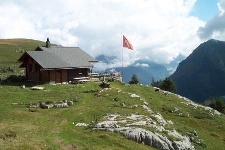
Lobhornhutte - SaxetenWalk 8030
Canton - Bern / Berne - Jungfrau Region
Author - Lou Johnson
Length - 7.0 km / 4.4 miles
Ascent - 150 metres / 495 feet
Descent - 870 metres / 2871 feet
Time - 3.50 hours
Grade - moderate/hard
Click image to visit gallery of 12 images.
This high level walk crosses the flanks of Bällenalp which rises to the south of Wilderswil. The walk includes some wonderful waterfalls and good views of the surrounding mountains with the final section following the valley floor to Saxeten.
Start the Lobhornhütte. This can be reached by following walk 8029 from Sulwald.
End the village of Saxeten. This village is served by infrequent postbuses that descend to the railway station in Wilderswil. See Transport Map for the Jungfrau Region.
From the Lobhornhütte take the path cutting across the main path going north from the lake of Sulsseelwli. The route is well marked although relatively little walked. After an initial climb the path drops and traverses across a scree slope of Tschingel to reach a broad col to the west of Bällehöchst (2095 m). From here make the short detour to the summit. The views are similar to those enjoyed elsewhere on the walk but you do get to experience the relatively lofty position of this excellent summit with a spectacular view down to Wilderswil.
From the broad col continue across alpine meadows to reach the small farm at Usser Ballen. The clear path descends towards the head of the valley passing another farm at Hinder Ballen. Losing height quickly in a series of zigzags the path reaches the main valley track at Underberg.
From here walk down the valley enjoying some wonderful waterfalls. Not far down the road bear right and cross the river to follow a signed footpath on the eastern banks of the river. As you near the village of Saxeten you will pass an interesting water-powered sawmill on your left. Reaching the road, turn left, cross the river and walk up into the village where a small hotel offers a variety of refreshments. Do be careful and ensure you know the bus times before setting out. The service is limited and infrequent. The time of for and half hours from Sulwald was achieved easily and excludes a time spent at the Lobhornhütte.
Suggested Maps
 Landeskarte der Schweiz - 1:50000 - Sheet SW 5004 - Berner Oberland
Landeskarte der Schweiz - 1:25000 - Sheet SW 2520 - Jungfrau Region
Wanderkarte - Wengen, Mürren & Lauterbrunnental - 1:40000
Recommended Books
The Swiss Alpine Pass Route - Via Alpina Route 1
 Guidebook to the Alpine Pass Route following the Swiss Via Alpina 1, a 360km trek east-west across Switzerland, from Sargans, on the border of Liechtenstein, to Montreux, including prologue from Liechtenstein. A demanding 3-week trek described in 18 stages, crossing 16 passes including the 2778m Hohtürli. Requires good fitness and experience.
Tour of the Jungfrau Region
 A guidebook to the Tour of the Jungfrau Region, a 111km trek from Schynige Platte to Wilderswil in 9-12 days through the Bernese Oberland under the Mönch, Eiger and Jungfrau, exploring both well-known and hidden valleys, surrounded by soaring peaks, glaciers, lakes and ridges. A good first Alpine trek with plenty of bad-weather alternatives.
Stay Safe
Do enjoy yourself when out walking and choose a route that is within your capabilities especially with regard to navigation.
Do turn back if the weather deteriorates especially in winter or when visibility is poor.
Do wear the right clothing for the anticipated weather conditions. If the weather is likely to change for the worse make sure you have enough extra clothing in your pack.
Do tell someone where you are planning to walk especially in areas that see few other walkers.
Do take maps and other navigational aids. Do not rely on mobile devices in areas where reception is poor. Take spare batteries especially in cold weather.
Do check the weather forecast before leaving.
Do do not exceed your capabilities.
Please Note - These walks have been published for use by site visitors on the understanding that Walking Sitzerland is not held responsible for the safety or well being of those following the routes as described. It is worth reiterating the point that you should embark on a walk with the correct maps at the most detailed scale where possible. This will enable any difficulties with route finding to be assessed, and corrective action taken if necessary.