Selden - Kanderfirn - SeldenWalk 8038
Canton - Bern / Berne - Kandertal
Author - Lou Johnson
Length - 10.0 km / 6.3 miles
Ascent - 900 metres / 2970 feet
Descent - 900 metres / 2970 feet
Time - 4.50 hours
Grade - moderate
Click image to visit gallery of 9 images.
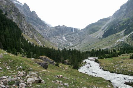
A wonderful walk that climbs through the Gastern Valley to the Kanderfirn Glacier. The views across the glacier are superb. Note that unusually for Switzerland there are no sources of refreshment apart from the start/end of the walk.
Start & End the Hotel Gasterntal, Selden. See Transport Map for the Kandertal Region. Please note the bus service is limited and reservations are recommended. Current information can be obtained from the Tourist Information Bureau in Kandersteg.
From the Hotel Gasternal continue up the valley on the main track to the farm at Heimritz. From this farm the path starts and begins to climb. The route crosses to the other side of the river where an alternative path from Heimritz joins. The path climbs onto a moraine with a steady ascent with a rock wall ahead. You will see the ice of the Alpetli Glacier (the nose of the Kanderfirn) glinting at the top of the rock wall. At the end of the moraine the path zigzags up through a rocky landscape to reach the glacier. Improved views of the glacier can be obtained by continuing further although you will reach the stage where further progress adds nothing to the view.
The initial part of the return to Selden follows the outward route. The descent from the glacier offers a grandstand view into the valley with the Balmhorn dominating the scene. Instead of crossing the river where you did on the outward route, continue downstream with the river on your right until you reach the farm at Heimritz. Here cross the footbridge and continue down the service track to Selden.
Suggested Maps
 Landeskarte der Schweiz - 1:50000 - Sheet SW 5004 - Berner Oberland
Landeskarte der Schweiz - 1:50000 - Sheet SW5009 - Gstaad - Adelboden
Kandersteg Wanderkarte - 1:25000
Recommended Books
The Swiss Alpine Pass Route - Via Alpina Route 1
 Guidebook to the Alpine Pass Route following the Swiss Via Alpina 1, a 360km trek east-west across Switzerland, from Sargans, on the border of Liechtenstein, to Montreux, including prologue from Liechtenstein. A demanding 3-week trek described in 18 stages, crossing 16 passes including the 2778m Hohtürli. Requires good fitness and experience.
The Tour of the Bernina
 Guidebook describing a 9-stage (119km) route around the Piz Bernina massif in the Alps on the Swiss-Italian border near St Moritz, and the 8-stage (94km) Alta Via Valmalenco exploring the Valmalenco valley, in the shadow of Monte Disgrazia. The Tour of the Bernina is suitable for first-time trekkers but the Alta Via needs some experience.
Stay Safe
Do enjoy yourself when out walking and choose a route that is within your capabilities especially with regard to navigation.
Do turn back if the weather deteriorates especially in winter or when visibility is poor.
Do wear the right clothing for the anticipated weather conditions. If the weather is likely to change for the worse make sure you have enough extra clothing in your pack.
Do tell someone where you are planning to walk especially in areas that see few other walkers.
Do take maps and other navigational aids. Do not rely on mobile devices in areas where reception is poor. Take spare batteries especially in cold weather.
Do check the weather forecast before leaving.
Do do not exceed your capabilities.
Please Note - These walks have been published for use by site visitors on the understanding that Walking Sitzerland is not held responsible for the safety or well being of those following the routes as described. It is worth reiterating the point that you should embark on a walk with the correct maps at the most detailed scale where possible. This will enable any difficulties with route finding to be assessed, and corrective action taken if necessary.