Sunnbuel - Uschenegrat - Schwarenbach - SunnbuelWalk 8039
Canton - Bern / Berne - Kandertal
Canton - Valais / Wallis - Leukerbad & Gemmipass
Author - Lou Johnson
Length - 11.0 km / 6.9 miles
Ascent - 630 metres / 2079 feet
Descent - 630 metres / 2079 feet
Time - 5.00 hours
Grade - moderate
Click image to visit gallery of 12 images.
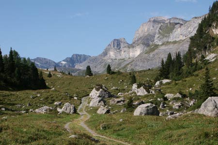
This walk follows the Üschenegrat ridge from where superb views are obtained of the surrounding valleys and mountains. The first part of the walk along the ridge is relatively quiet before you drop down to the Berghotel Schwarenbach from where a much busier path leads through the valley back to the start.
Start & End the upper station of the Luftseilbahn Kandersteg-Sunnbüel. See Transport Map for the Kandertal Region.
Exit the upper station of the Luftseilbahn Kandersteg-Sunnbüel and bear right to reach a path junction at Winteregg. Go straight across and start to climb across the eastern flank of the Gällihorn. As you climb higher the path zigzags across steeper ground to reach a viewpoint (2165m). The view from here is excellent with the Kander Valley laid out at your feet. The view also includes a wide panorama of mountain peaks from the Bunderspitz to the Attels.
To continue ignore the paths down into the valley and to the summit of the Gällihorn and continue along the Üschenegrat ridge. The views once more are superb especially into the Inner Üschene valley on your right. Continue along the ridge for over 4 kilometres towards the head of the valley. After crossing the flank of the Wyssi Flue the path descends to a col and a junction of paths. Turn left here to Schwarenbach.
The route crosses alpine meadows before descending in a series of loops and zigzags to join the main path near the Berghotel Schwarenbach. Turn left here and the Berghotel is a few minutes walk. However if you have time and the energy it is worth turning right and continuing as far as the shores of the Daubensee.
From Schwarenbach follow the main path through a narrow rocky valley before descending into a wider valley. The main path, now a track, continues without any further navigational difficulties all the way back to the start of the walk.
Suggested Maps
 Landeskarte der Schweiz - 1:50000 - Sheet SW 5004 - Berner Oberland
Landeskarte der Schweiz - 1:50000 - Sheet SW5009 - Gstaad - Adelboden
Kandersteg Wanderkarte - 1:25000
Recommended Books
The Swiss Alpine Pass Route - Via Alpina Route 1
 Guidebook to the Alpine Pass Route following the Swiss Via Alpina 1, a 360km trek east-west across Switzerland, from Sargans, on the border of Liechtenstein, to Montreux, including prologue from Liechtenstein. A demanding 3-week trek described in 18 stages, crossing 16 passes including the 2778m Hohtürli. Requires good fitness and experience.
Tour of the Matterhorn
 A guide to the 145km Tour of the Matterhorn, described anti-clockwise from Zermatt and visits 6 valleys via Zinal, Arolla and Breuil, offering spectacular views of 25 peaks of over 4000m. The route also links up with the Chamonix to Zermatt walkers' Haute Route and the Tour of Monte Rosa. Includes two glacier crossings and takes 8 to 10 days.
Stay Safe
Do enjoy yourself when out walking and choose a route that is within your capabilities especially with regard to navigation.
Do turn back if the weather deteriorates especially in winter or when visibility is poor.
Do wear the right clothing for the anticipated weather conditions. If the weather is likely to change for the worse make sure you have enough extra clothing in your pack.
Do tell someone where you are planning to walk especially in areas that see few other walkers.
Do take maps and other navigational aids. Do not rely on mobile devices in areas where reception is poor. Take spare batteries especially in cold weather.
Do check the weather forecast before leaving.
Do do not exceed your capabilities.
Please Note - These walks have been published for use by site visitors on the understanding that Walking Sitzerland is not held responsible for the safety or well being of those following the routes as described. It is worth reiterating the point that you should embark on a walk with the correct maps at the most detailed scale where possible. This will enable any difficulties with route finding to be assessed, and corrective action taken if necessary.