Gemmipass - Daubensee - GemmipassWalk 8041
Canton - Valais / Wallis - Leukerbad & Gemmipass
Author - Lou Johnson
Length - 6.0 km / 3.8 miles
Ascent - 120 metres / 396 feet
Descent - 120 metres / 396 feet
Time - 2.50 hours
Grade - easy/moderate
Click image to visit gallery image.
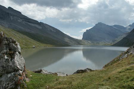
This route makes a complete circuit of the Daubensee using the cable car from Leukerbad to gain height above the Rhone Valley to the Gemmi Pass.
Start & End the upper station of the Gemmibahn from Leukerbad to the Gemmi Pass. See Transport Map for the Kandertal Region.
Exit the upper station of the Gemmibahn and make your way to the pass. The view over the Rhone Valley and the Alps beyond is a one of the great panoramas in Europe with dozens of well known peaks included in the picture. From here descend to the shores of the Daubensee following the path to the Berghotel Schwarenbach.
Continue along the shore to reach its northern end where you leave the main path and continue along the western shores of the lake. This side of the Daubensee is much quieter and there are a number of points where you can rest and enjoy the view spoilt somewhat by the electricity power lines strung across the mountainside. With a complete circuit of the lake nearly complete continue up to the pass and enjoy the view again before descending back to Leukerbad.
If you require refreshments then you can stay on the main path at the northern end of the lake and continue the short distance to the Berghotel Schwarenbach. To complete the route return to the lake and bear right and continue the walk as described above.
Suggested Maps
 Landeskarte der Schweiz - 1:50000 - Sheet SW 5004 - Berner Oberland
Landeskarte der Schweiz - 1:50000 - Sheet SW5009 - Gstaad - Adelboden
Kandersteg Wanderkarte - 1:25000
Recommended Books
Walking in the Valais
 Comprehensive guidebook to the Valais region, describing 111 day walks and 10 multi-day tours. Home to the Matterhorn and Dent Blanche, the routes are in the Fieschertal and the Aletsch glacier region, the Lötschental, Saastal, Mattertal, Turtmanntal, Val d'Anniviers, Val d'Herens, Val de Bagnes, Val Ferret and Vallée du Trient.
Alpine Flowers
 A pocket field guidebook for identifying 230 of the most commonly found alpine flowers of the Alps. Categorised by colour for quick identification, each alpine flower has a photograph and description of its key features. Flower names are given in English, French, German, Italian and Latin, with notes on curious facts and origins of names.
Stay Safe
Do enjoy yourself when out walking and choose a route that is within your capabilities especially with regard to navigation.
Do turn back if the weather deteriorates especially in winter or when visibility is poor.
Do wear the right clothing for the anticipated weather conditions. If the weather is likely to change for the worse make sure you have enough extra clothing in your pack.
Do tell someone where you are planning to walk especially in areas that see few other walkers.
Do take maps and other navigational aids. Do not rely on mobile devices in areas where reception is poor. Take spare batteries especially in cold weather.
Do check the weather forecast before leaving.
Do do not exceed your capabilities.
Please Note - These walks have been published for use by site visitors on the understanding that Walking Sitzerland is not held responsible for the safety or well being of those following the routes as described. It is worth reiterating the point that you should embark on a walk with the correct maps at the most detailed scale where possible. This will enable any difficulties with route finding to be assessed, and corrective action taken if necessary.