Fuorcla Surlej - Restaurant Roseg Walk 8058
Canton - Graubunden/Grisons - Upper Engadine
Author - Lou Johnson
Length - 3.0 km / 1.9 miles
Ascent - nominal or unknown
Descent - 725 metres / 2393 feet
Time - 1.25 hours
Grade - easy
Click image to visit gallery of 12 images.
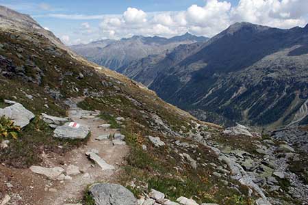
An easy route that is downhill all the way! The start is the refuge at Fuorcla Surlej (2755 m) with its magnificent position and wonderful mountain panoramas. You can reach this point by following Walk 8057 by taking a cable car to Murtel from Surlej.
Descend on the path past the small lake to the first junction (2722 m). Turn left and descend gently across the valley side with excellent to the head of the valley. Soon the valley floor comes into view and you also get a distant view of Lej da Vadret too.
The descent is across open mountainside with an occasional small chalet adding scale to the scene. As you descend the path threads its way through trees before eventually reaching the valley floor with the river split into many smaller streams. Joining the valley path (2022 m) you have about a kilometre to walk before reaching the Hotel Restaurant Roseg.
To continue follow walk 8073 back to Pontresina.
Suggested Maps
 Oberengadin, Bergell-Puschlav, Wanderkarte - 1:50000
Recommended Books
Walking in the Alps
 An outstanding and comprehensive book exploring the walking and trekking possibilities in every Alpine region. Many thousands of possible routes are suggested, from the Maritime Alps of southern France throughout the range to the Julian Alps of Slovenia. Walks vary from undemanding to long and tough, and everything in between.
Walking in the Valais
 Comprehensive guidebook to the Valais region, describing 111 day walks and 10 multi-day tours. Home to the Matterhorn and Dent Blanche, the routes are in the Fieschertal and the Aletsch glacier region, the Lötschental, Saastal, Mattertal, Turtmanntal, Val d'Anniviers, Val d'Herens, Val de Bagnes, Val Ferret and Vallée du Trient.
Stay Safe
Do enjoy yourself when out walking and choose a route that is within your capabilities especially with regard to navigation.
Do turn back if the weather deteriorates especially in winter or when visibility is poor.
Do wear the right clothing for the anticipated weather conditions. If the weather is likely to change for the worse make sure you have enough extra clothing in your pack.
Do tell someone where you are planning to walk especially in areas that see few other walkers.
Do take maps and other navigational aids. Do not rely on mobile devices in areas where reception is poor. Take spare batteries especially in cold weather.
Do check the weather forecast before leaving.
Do do not exceed your capabilities.
Please Note - These walks have been published for use by site visitors on the understanding that Walking Sitzerland is not held responsible for the safety or well being of those following the routes as described. It is worth reiterating the point that you should embark on a walk with the correct maps at the most detailed scale where possible. This will enable any difficulties with route finding to be assessed, and corrective action taken if necessary.