Swiss National Park from S-chanf Walk 8066
Canton - Graubunden/Grisons - Lower Engadine
Author - Lou Johnson
Ascent - nominal or unknown
Descent - nominal or unknown
Time - 6.00 hours
Grade - moderate
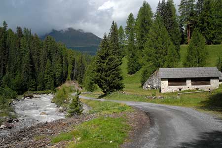
Click image to visit gallery of 12 images.
Switzerland has only one National Park in Switzerland (with plans to create more) and is the largest protected area of the country. Inaugurated in 1914, it was one of the first national parks in Europe. Strict rules apply and it is forbidden to disturb the animals and plants. Located close to the village S-chanf, which has a regular train service, the walk to the park entrance from the station takes about 45 minutes. There is a limited bus service but you need to check times to and from the park before planning your walk.
From the park entrance and café at Prasüs you initially have a choice of either following a gravel track or a forest path. The former is probably better as the views from the path are more open. Walk up the track and continue past Mulins, Varusch and the Punt da Val da Scrigns. Do not cross the bridge but continue straight ahead for 100 metres and take the path on the left towards the Parkhütte Varusch, where a range of food and refreshments are available.
From the Parkhütte there is a single path up the valley so navigation is never an issue. You will reach another bridge (1858 metres) at Alp Purcher. Cross the bridge and turn left (with the river on your left). You soon reach another bridge (1878 metres). Cross this bridge and just before the second bridge go right following a narrow path signed to Alp Trupchun.
The path climbs gently with superb views to the river on your right. Reaching the final bridge (1995 metres), continue upstream as far as you wish. The higher you go the more chance you have of seeing wildlife as the number of visitors drops significantly as you go higher. Despite relatively poor weather we saw marmot, chamoix and ibex about 30 minutes upstream from this bridge.
The return route follows the outward route. However there are other paths you can use in descent and the 1:25000 map will help you explore the area in more detail.
Suggested Maps
 Landeskarte der Schweiz - 1:25000 - Sheet 1238 - Piz Quattervals
Recommended Books
Tour of Mont Blanc
 An essential guidebook for walking the Tour of Mont Blanc. The 170km route typically takes 11 days to trek around the Mont Blanc massif. The TMB is recognised as one of the world's classic treks. The book describes both anti-clockwise and clockwise directions, with variants and information about huts, refuges and facilities en route.
Walking in the Bernese Oberland
 This walking guidebook to the Bernese Oberland describes 113 day walks. Routes range from 2 to 24km and offer breathtaking scenery of the classic Eiger, Mönch and Jungfrau mountains, around Grindelwald, Lauterbrunnen, Gsteig and Meiringen. There are routes suitable for all abilities from short flat walks to adventurous treks.
Stay Safe
Do enjoy yourself when out walking and choose a route that is within your capabilities especially with regard to navigation.
Do turn back if the weather deteriorates especially in winter or when visibility is poor.
Do wear the right clothing for the anticipated weather conditions. If the weather is likely to change for the worse make sure you have enough extra clothing in your pack.
Do tell someone where you are planning to walk especially in areas that see few other walkers.
Do take maps and other navigational aids. Do not rely on mobile devices in areas where reception is poor. Take spare batteries especially in cold weather.
Do check the weather forecast before leaving.
Do do not exceed your capabilities.
Please Note - These walks have been published for use by site visitors on the understanding that Walking Sitzerland is not held responsible for the safety or well being of those following the routes as described. It is worth reiterating the point that you should embark on a walk with the correct maps at the most detailed scale where possible. This will enable any difficulties with route finding to be assessed, and corrective action taken if necessary.