Guarda - Lavin - Susch Walk 8067
Canton - Graubunden/Grisons - Lower Engadine
Author - Lou Johnson
Length - 11.3 km / 7.1 miles
Ascent - nominal or unknown
Descent - 250 metres / 825 feet
Time - 3.50 hours
Grade - easy
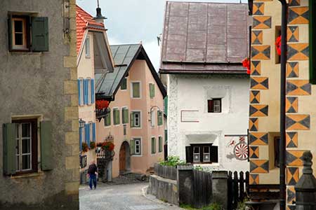
Click image to visit gallery of 15 images.
This an easy walk uses mainly tracks between three attractive villages in the Lower Engadine. It is an ideal walk to fill half a day especially when it has been raining or when the mountains are covered in cloud. The villages are linked by a frequent and regular service of trains along the valley. However, Guard village lies some 250 metres above the railway station and is reached by a steep path. Subject to continued patronage there is a limited post bus service meeting some trains and linking Guarda's station with the village.
Little in the way of description is need to describe the walk. However, of the three villages Guarda is probably the most attractive and is worth spending time exploring the streets with their many solid houses dating back many centuries. Some have external decoration whilst details of some of the construction dates are presented on the walls of the houses.
Exploration complete follow the lower of the two main streets through the village as far as the first hairpin bend on the road down into the valley. Leave the road here and follow the track into the side valley. Cross the first bridge over the La Cloxxa river, continuing across open pastures on a clear track down to Lavin. At the first junction we took the left-hand fork and this led steadily downhill towards the village of Lavin.
Descend through the village and cross the covered bridge over the River En. Turn first left and take the track running closest to the river. Ignore all braches off to the left and continue to the eastern edge of Susch village. As you approach the tracks turns sharp left to a road. Turn right along this road, cross the river and you have arrived in solidly built village centre. For those using the valley train service, the station is approached by a rising road on your right just after crossing the river.
Suggested Maps
 Landeskarte der Schweiz - 1:25000 - Sheet 1238 - Piz Quattervals
Recommended Books
Walking in the Bernese Oberland
 This walking guidebook to the Bernese Oberland describes 113 day walks. Routes range from 2 to 24km and offer breathtaking scenery of the classic Eiger, Mönch and Jungfrau mountains, around Grindelwald, Lauterbrunnen, Gsteig and Meiringen. There are routes suitable for all abilities from short flat walks to adventurous treks.
100 Hut Walks in the Alps
 This guidebook has route descriptions for 100 day walks to suit alpine walkers of all abilities, with suggestions for some hut-to-hut tours. These routes take you through breathtaking scenery in the Maritime Alps, Julian Alps, Gran Paradiso, the Turnitzer Alps, Bernese Oberland, the Kitzbuheler Alps and the Dolomites of South Tirol.
Stay Safe
Do enjoy yourself when out walking and choose a route that is within your capabilities especially with regard to navigation.
Do turn back if the weather deteriorates especially in winter or when visibility is poor.
Do wear the right clothing for the anticipated weather conditions. If the weather is likely to change for the worse make sure you have enough extra clothing in your pack.
Do tell someone where you are planning to walk especially in areas that see few other walkers.
Do take maps and other navigational aids. Do not rely on mobile devices in areas where reception is poor. Take spare batteries especially in cold weather.
Do check the weather forecast before leaving.
Do do not exceed your capabilities.
Please Note - These walks have been published for use by site visitors on the understanding that Walking Sitzerland is not held responsible for the safety or well being of those following the routes as described. It is worth reiterating the point that you should embark on a walk with the correct maps at the most detailed scale where possible. This will enable any difficulties with route finding to be assessed, and corrective action taken if necessary.